|
search place name
|
||
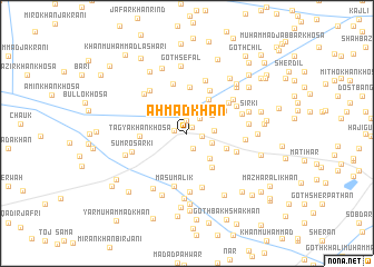
Ahmad Khān (Sind, Pakistan)Ahmad Khān is a town in the Sind region of Pakistan. An overview map of the region around Ahmad Khān is displayed below.
regional and 3d topo map of Ahmad Khān, Pakistan ::
Ahmad Khān airports ::
The nearest airport is SUL - Sui, located 43.5 km north of Ahmad Khān.
Other airports nearby include SKZ - Sukkur (65.6 km south), RYK - Rahim Yar Khan Sheikh Zayed (124.9 km east), MJD - Moenjodaro (135.2 km south west), JSA - Jaisalmer (239.4 km south east), Nearby towns ::
Heibat Shahid (0.7km north east) //
Malūk Jakrāni (1.2km north) //
Tangwāni (1.1km west) //
Muhammad Hayāt (1.4km east) //
Rasulābād (1.6km south) //
Sakku (1.9km north east) //
Dādu Khosa (2.5km north) //
Etbār Khān (2.4km south east) //
Sohbat Gola (2.5km east) //
Chāchar (2.9km north east) //
Nasīr Khān (3.2km south east) //
Goth Hot Khān Bakrāni (3.9km north east) //
Jallo Khān (4.0km south east) //
Sher Dil Khān (3.9km south east) //
Sher Dil Khosa (4.0km north east) //
Goth Hakīm Khān Naunāri (4.6km north) //
Tagya Khān Khosa (4.2km west) //
Goth Gano Khosa (4.8km north east) //
Taj Muhammad Baqrāni (5.1km north) //
Muhammad Amīn Gabol (4.8km north east) //
Muhammad Khān Bājkani (4.7km south east) //
Masu Malik (5.4km south) //
Goth Karīm Bakhsh Khosa (5.5km north) //
Goth Lashkar Khān (5.6km south) //
Jām Khosa (5.2km north east) //
Kundha Baqrāni (5.4km north west) //
Khair Bakhsh Gabol (5.3km north east) //
Sumro Sarki (5.2km west) //
Amīr Bakhsh (5.9km south) //
[all distances 'as the bird flies' and approximate]  Places with similar names to Ahmad Khān, Pakistan ::
// Aḩmadkhān (IR)
// Aḩmad Khānī (IR)
// Ahmad Khān (PK)
// Ahmad Khān (PK)
// Ahmad Khān (PK)
// Ahmad Khān (PK)
// Ahmad Khān (PK)
// Ahmad Khān (PK)
// Ahmad Khān (PK)
Disclaimer :: Information on this page comes without warranty of any kind |
||
|
Where is Ahmad Khān? Elevation and coordinates ::
Latitude (lat): 28°16'50"N Longitude (lon): 69°0'40"E
Elevation (approx.): 65m (map arrows pan, magnifying glasses zoom) |
||
|
Visiting Ahmad Khān? Hotel/Accommodation ::
Book a hotel in Ahmad Khān Travel Guide ::
Buy a travel guide for Pakistan rental cars ::
car rental offers GPS waypoint ::
download a GPX waypoint (PoI) of Ahmad Khān for your GPS receiver
|
||