|
search place name
|
||
Bānda Nikki Pail (North-West Frontier, Pakistan)Bānda Nikki Pail is a town in the North-West Frontier region of Pakistan. An overview map of the region around Bānda Nikki Pail is displayed below.
regional and 3d topo map of Bānda Nikki Pail, Pakistan ::

Bānda Nikki Pail airports ::
The nearest airport is PEW - Peshawar Intl, located 104.9 km north east of Bānda Nikki Pail.
Other airports nearby include JAA - Jalalabad (136.5 km north), KBL - Kabul Intl (215.4 km north west), SDT - Saidu Sharif (223.8 km north east), PZH - Zhob (245.0 km south west), Nearby towns ::
Bānda Seri Chera (0.2km north) //
Dabāra (2.2km west) //
Bānda Pilah (2.2km west) //
Bānda Ghol (3.3km south east) //
Ibrāhīm Kili (4.0km south) //
Mīr Hasan Kili (4.9km south east) //
NiāzKili (5.0km south east) //
Drish Khel (5.1km east) //
Sra Rāgha (5.2km west) //
Zauki Kalān (6.0km south west) //
Shahīdan Dargāh (6.4km west) //
Liwānai Pail (6.5km east) //
Misal Khān Kili (8.2km north) //
Bahādur Khel (7.5km south east) //
Marūf Khān Kili (8.8km north) //
Bomi Bānda (9.1km north west) //
Bakha Bānda (9.2km north east) //
Sarobe (9.5km south west) //
[all distances 'as the bird flies' and approximate] 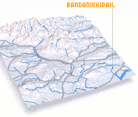 Places with similar names to Bānda Nikki Pail, Pakistan :: Disclaimer :: Information on this page comes without warranty of any kind |
||
|
Where is Bānda Nikki Pail? Elevation and coordinates ::
Latitude (lat): 33°12'39"N Longitude (lon): 70°52'51"E
Elevation (approx.): 640m (map arrows pan, magnifying glasses zoom) |
||
|
Visiting Bānda Nikki Pail? Hotel/Accommodation ::
Book a hotel in Bānda Nikki Pail Travel Guide ::
Buy a travel guide for Pakistan rental cars ::
car rental offers GPS waypoint ::
download a GPX waypoint (PoI) of Bānda Nikki Pail for your GPS receiver
|
||