|
search place name
|
||
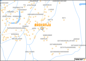
Bao Kanju (Sind, Pakistan)Bao Kanju is a town in the Sind region of Pakistan. An overview map of the region around Bao Kanju is displayed below.
regional and 3d topo map of Bao Kanju, Pakistan ::
Bao Kanju airports ::
The nearest airport is RYK - Rahim Yar Khan Sheikh Zayed, located 66.9 km north east of Bao Kanju.
Other airports nearby include SUL - Sui (85.4 km north west), SKZ - Sukkur (97.9 km west), JSA - Jaisalmer (170.8 km south east), MJD - Moenjodaro (174.0 km south west), Nearby towns ::
Gullan Kanjo (0.5km south east) //
Ghulām Ali Dahar (1.4km north east) //
Allāhjiwāya Bhutto (1.5km west) //
Nūr Muhammad Drokhan (1.7km north east) //
Khairpur (2.0km north west) //
Hāji Kānjo (2.4km north east) //
Sāhib Dino Rājri (3.0km south) //
Soba Kābar (3.4km south east) //
Jung (3.4km west) //
Gohrām (4.0km north east) //
Goth Malko (3.9km south west) //
Akbarābād (3.9km north west) //
Bakhsh Bhatti (4.2km north west) //
Sāidīno Malik (4.4km north) //
Tāhīrio Tāunri (4.5km north) //
Iso Rājri (4.5km south) //
Wāhi Gul Khān (4.3km south west) //
Abdullāh Rajri (4.6km south) //
Goth Kālu Burira (4.2km west) //
Hāfiz Sulaimān (4.8km north) //
Sattār Darkhān (5.0km north) //
Goth Shahbāz (4.7km south west) //
Katto (4.8km north east) //
Bhur Chundi Sharīf (4.9km north west) //
Sumār Tāunri (5.4km north) //
Goth Jān Muhammad Faqīr (5.6km south west) //
Kotia Mirzan (5.6km west) //
Arzi Bhutto (6.6km north) //
Fatehpur (6.2km south west) //
[all distances 'as the bird flies' and approximate]  Places with similar names to Bao Kanju, Pakistan ::
Disclaimer :: Information on this page comes without warranty of any kind |
||
|
Where is Bao Kanju? Elevation and coordinates ::
Latitude (lat): 28°2'30"N Longitude (lon): 69°43'5"E
Elevation (approx.): 74m (map arrows pan, magnifying glasses zoom) |
||
|
Visiting Bao Kanju? Hotel/Accommodation ::
Book a hotel in Bao Kanju Travel Guide ::
Buy a travel guide for Pakistan rental cars ::
car rental offers GPS waypoint ::
download a GPX waypoint (PoI) of Bao Kanju for your GPS receiver
|
||