|
search place name
|
||
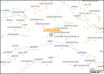
Chrohīa (North-West Frontier, Pakistan)Chrohīa is a town in the North-West Frontier region of Pakistan. An overview map of the region around Chrohīa is displayed below.
regional and 3d topo map of Chrohīa, Pakistan ::
Chrohīa airports ::
The nearest airport is PZH - Zhob, located 109.3 km west of Chrohīa.
Other airports nearby include MUX - Multan Intl (179.4 km south east), Nearby towns ::
Sikandra (1.4km west) //
Māro (2.4km south) //
Garah Murid Shāh (2.9km east) //
Garah Khokhar (3.5km north east) //
Garah Īsa Khān (4.8km north west) //
Jhok Masu Khān (5.0km south east) //
Garah Baluch Kāwānwāla (4.6km east) //
Gandi Umar Khān (6.5km north) //
Garah Miān Fateh Muhammad (6.8km north east) //
Zamān Tilokar (6.6km north east) //
Garah Baluch (7.1km north west) //
Garah Rashīd (6.8km south east) //
Bābrān (7.2km south west) //
Garah Bishārat (7.3km north east) //
Moga (8.3km south) //
Adha Khiārah (7.9km north east) //
Gara Mīr Alam Khān (7.7km west) //
Garah Ālam Khān (10.2km north west) //
[all distances 'as the bird flies' and approximate] 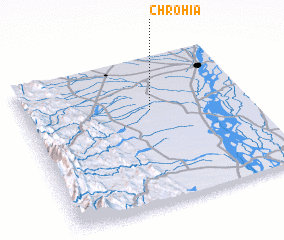 Places with similar names to Chrohīa, Pakistan ::
Disclaimer :: Information on this page comes without warranty of any kind |
||
|
Where is Chrohīa? Elevation and coordinates ::
Latitude (lat): 31°38'37"N Longitude (lon): 70°33'52"E
Elevation (approx.): 186m (map arrows pan, magnifying glasses zoom) |
||
|
Visiting Chrohīa? Hotel/Accommodation ::
Book a hotel in Chrohīa Travel Guide ::
Buy a travel guide for Pakistan rental cars ::
car rental offers GPS waypoint ::
download a GPX waypoint (PoI) of Chrohīa for your GPS receiver
|
||