|
search place name
|
||
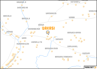
Dakasi (Punjab, Pakistan)Dakasi is a town in the Punjab region of Pakistan. An overview map of the region around Dakasi is displayed below.
regional and 3d topo map of Dakasi, Pakistan ::
Dakasi airports ::
The nearest airport is PEW - Peshawar Intl, located 105.4 km north east of Dakasi.
Other airports nearby include JAA - Jalalabad (114.7 km north), KBL - Kabul Intl (187.6 km north west), SDT - Saidu Sharif (223.8 km north east), Nearby towns ::
Mīrmast Kili (0.8km south) //
Lahori Kili (1.4km south east) //
Mazrīn (1.5km south) //
Zor Mazrīn (1.8km south) //
Dallan (1.8km south) //
Kar Kumai (2.2km south east) //
Mamun (3.4km north west) //
Ganderi (4.7km south east) //
Akram Bānda (4.7km west) //
Khān Bānda (4.9km west) //
Kaparluta (5.4km south west) //
Kanra Chīna (5.6km north east) //
Abbāsi Bānda (5.5km west) //
Bānda Shinkai (6.6km south) //
Chaprai (6.2km south west) //
Banda Rakhmat Shāh (5.6km west) //
Halīm Bānda (5.7km west) //
Darsamand (7.2km north) //
Jowaro Ghundai (7.3km north east) //
Shinala Talao (7.5km east) //
Banzola (8.8km north west) //
[all distances 'as the bird flies' and approximate]  Places with similar names to Dakasi, Pakistan ::
Disclaimer :: Information on this page comes without warranty of any kind |
||
|
Where is Dakasi? Elevation and coordinates ::
Latitude (lat): 33°22'26"N Longitude (lon): 70°39'11"E
Elevation (approx.): 886m (map arrows pan, magnifying glasses zoom) |
||
|
Visiting Dakasi? Hotel/Accommodation ::
Book a hotel in Dakasi Travel Guide ::
Buy a travel guide for Pakistan rental cars ::
car rental offers GPS waypoint ::
download a GPX waypoint (PoI) of Dakasi for your GPS receiver
|
||