|
search place name
|
||
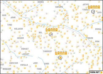
Danna (Pakistan)Danna is a town in Pakistan. An overview map of the region around Danna is displayed below.
regional and 3d topo map of Danna, Pakistan ::
Danna airports ::
The nearest airport is MFG - Muzaffarabad, located 31.0 km north west of Danna.
Other airports nearby include RAZ - Rawala Kot Rawalakot (32.6 km south), ISB - Islamabad Chaklala (83.3 km south west), SXR - Srinagar (96.6 km east), SDT - Saidu Sharif (148.1 km north west), Nearby towns ::
Parhor (0.3km north) //
Bani Hāfiz (0.3km south) //
Khole (0.8km east) //
Bāndi Hāfiz (1.4km south west) //
Nāto Garang (1.4km south east) //
Sarbagia (1.3km east) //
Nāla (1.6km north) //
Dāndbeh (1.5km west) //
Falāti (2.1km north west) //
Dowāiyān (2.4km north) //
Lasdār (2.5km north) //
Bāt Bīni (2.3km north east) //
Nainān (2.3km north west) //
Ūrni (2.5km south east) //
Batsir (2.3km west) //
Hotreri (2.6km south east) //
Dhandi Shāhadāra (2.8km north) //
Salmeāh (2.8km south) //
Hariāla (2.6km south west) //
Nainsukh (2.9km north west) //
Hatiān (3.1km north) //
Dabar (3.0km north east) //
Chandkot (3.3km north) //
Jigal (3.4km north) //
Bāndi Muhri (3.0km east) //
Jabar Jandali (3.5km south) //
Kailan (3.3km north east) //
Sin Dhakki (3.3km south east) //
Bani Lungriālān (3.6km south east) //
[all distances 'as the bird flies' and approximate] 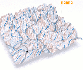 Places with similar names to Danna, Pakistan ::
Disclaimer :: Information on this page comes without warranty of any kind |
||
|
Where is Danna? Elevation and coordinates ::
Latitude (lat): 34°8'25"N Longitude (lon): 73°44'40"E
Elevation (approx.): 1586m (map arrows pan, magnifying glasses zoom) |
||
|
Visiting Danna? Hotel/Accommodation ::
Book a hotel in Danna Travel Guide ::
Buy a travel guide for Pakistan rental cars ::
car rental offers GPS waypoint ::
download a GPX waypoint (PoI) of Danna for your GPS receiver
|
||