|
search place name
|
||
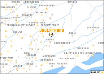
Daulatābād (Punjab, Pakistan)Daulatābād is a town in the Punjab region of Pakistan. An overview map of the region around Daulatābād is displayed below.
regional and 3d topo map of Daulatābād, Pakistan ::
Daulatābād airports ::
The nearest airport is LYP - Faisalabad Intl, located 131.6 km north of Daulatābād.
Other airports nearby include MUX - Multan Intl (152.3 km west), LHE - Lahore Allama Iqbal Intl (200.5 km north east), ATQ - Amritsar (241.5 km north east), Nearby towns ::
Nūrpur (1.9km south) //
Chak One Hundred Thirteen (2.7km west) //
Chak Ninety-three (3.4km north) //
Shekhūpura (3.3km north west) //
Chak One Hundred Five (3.5km south) //
Chak One Hundred Twenty-three (3.6km south west) //
Chak One Hundred Eleven (3.4km west) //
Chak One Hundred Twenty-one (3.9km south west) //
Chak One Hundred Eleven (4.1km north west) //
Chak Mahdi Khān (4.5km south east) //
Dargāh Nek Pāk (4.8km west) //
Sangat Singh (5.5km south west) //
Chak One Hundred Thirty-one (6.1km south west) //
Chak One Hundred Nineteen (5.7km west) //
Chak One Hundred Nine (5.9km north west) //
Chak Ninety-five (6.3km north west) //
Ahniānwāla (6.8km north) //
Chak Ninety-one (6.7km north west) //
Qabūla (6.4km east) //
Chak One Hundred Fifteen (6.7km west) //
Jumman Shāh (7.8km south) //
Chak One Hundred Seventeen (6.9km west) //
Darbārpur (8.0km north) //
Chak Two Hundred Thirty-seven (7.2km south west) //
Chak Two Hundred Nine (7.8km north west) //
Chak One Hundred Twenty-nine (7.5km south west) //
Jhajra (8.3km south east) //
Kot Khālsa (8.6km north) //
Chak One Hundred Twenty-seven (8.0km south west) //
[all distances 'as the bird flies' and approximate]  Places with similar names to Daulatābād, Pakistan ::
// Dowlatābād (IR)
// Dowlatābād (IR)
// Dowlatābād (IR)
// Dowlatābād (IR)
// Dowlatābād (IR)
// Dowlatābād (IR)
// Dowlatābād (IR)
// Dowlatābād (IR)
// Dowlatābād (IR)
// Dowlatābād (IR)
Disclaimer :: Information on this page comes without warranty of any kind |
||
|
Where is Daulatābād? Elevation and coordinates ::
Latitude (lat): 30°10'40"N Longitude (lon): 73°0'0"E
Elevation (approx.): 150m (map arrows pan, magnifying glasses zoom) |
||
|
Visiting Daulatābād? Hotel/Accommodation ::
Book a hotel in Daulatābād Travel Guide ::
Buy a travel guide for Pakistan rental cars ::
car rental offers GPS waypoint ::
download a GPX waypoint (PoI) of Daulatābād for your GPS receiver
|
||