|
search place name
|
||
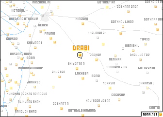
Drābi (Sind, Pakistan)Drābi is a town in the Sind region of Pakistan. An overview map of the region around Drābi is displayed below.
regional and 3d topo map of Drābi, Pakistan ::
Drābi airports ::
The nearest airport is BDN - Talhar, located 109.7 km south west of Drābi.
Other airports nearby include WNS - Nawabshah (176.9 km north west), JSA - Jaisalmer (207.1 km north east), BHJ - Bhuj (220.9 km south), Nearby towns ::
Bhīyon Tar (2.5km south west) //
Rodhār (3.1km east) //
Lākheba (4.5km south) //
Lākheba (4.5km south) //
Jāgoro (5.5km north east) //
Khalriabah (5.8km north east) //
Bānai (6.0km south east) //
Bānai (6.0km south east) //
Akla Tar (6.2km south west) //
Akla Tar (6.2km south west) //
Motisaro (6.7km north west) //
Kacholi Bhīl (7.0km east) //
Hingoro (8.0km north) //
Nenihār (7.4km east) //
Padrio (7.9km north west) //
Nenihār Bajīr (8.0km south east) //
Hāji Bhīl jo Goth (8.7km south west) //
Hāji Bhīl jo Goth (8.7km south west) //
Morāsio (9.0km south east) //
Morāsio (9.0km south east) //
Dehra (10.2km north west) //
[all distances 'as the bird flies' and approximate] 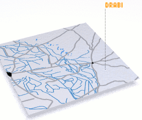 Places with similar names to Drābi, Pakistan ::
Disclaimer :: Information on this page comes without warranty of any kind |
||
|
Where is Drābi? Elevation and coordinates ::
Latitude (lat): 25°16'40"N Longitude (lon): 69°48'50"E
Elevation (approx.): 34m (map arrows pan, magnifying glasses zoom) |
||
|
Visiting Drābi? Hotel/Accommodation ::
Book a hotel in Drābi Travel Guide ::
Buy a travel guide for Pakistan rental cars ::
car rental offers GPS waypoint ::
download a GPX waypoint (PoI) of Drābi for your GPS receiver
|
||