|
search place name
|
||
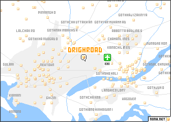
Drigh Road (Sind, Pakistan)Drigh Road is a town in the Sind region of Pakistan. An overview map of the region around Drigh Road is displayed below.
regional and 3d topo map of Drigh Road, Pakistan ::
Drigh Road airports ::
The nearest airport is KHI - Karachi Jinnah Intl, located 4.5 km east of Drigh Road.
Other airports nearby include BDN - Talhar (174.1 km east), WNS - Nawabshah (194.3 km north east), Nearby towns ::
Goth Nāthe Khān (2.5km south east) //
Goth Iqbāl (3.1km north west) //
Goth Zagri (3.0km north east) //
Pinjrāpur (3.4km west) //
Drigh Colony (3.5km south east) //
Dhoraji Colony (3.8km west) //
Goth Hāji Lemūn Khān (4.6km north west) //
Goth Azīm Khān (4.6km north west) //
Dastgīr Colony (4.9km north west) //
Goth Ramzān Khān (5.4km north east) //
Goth Warayo Gado (5.0km west) //
Goth Dost Muhammad (5.3km north west) //
Goth Fīroz Khān (5.4km north west) //
Goth Allāh Bakhsh (5.3km south east) //
Azīzābād (5.2km north west) //
Nātho Khān Khoso (5.3km east) //
Goth Allāhdād Khān (5.5km west) //
Goth Abdul Qādir (6.1km south) //
Goth Shāh Ali (5.8km south east) //
Bahādurābād (5.7km west) //
Goth Sohrāb Khān (6.1km north west) //
Goth Baloch Khān (6.2km north east) //
Mahmūdābād (6.2km south west) //
Goth Chhoti Khān (6.3km south west) //
Goth Bari Khān (6.3km south west) //
Goth Chhutta Khān (6.5km north east) //
Goth Shambah (6.5km south east) //
Liaquatābād (6.7km west) //
Goth Nagmān (6.7km west) //
[all distances 'as the bird flies' and approximate]  Places with similar names to Drigh Road, Pakistan ::
Disclaimer :: Information on this page comes without warranty of any kind |
||
|
Where is Drigh Road? Elevation and coordinates ::
Latitude (lat): 24°54'0"N Longitude (lon): 67°7'0"E
Elevation (approx.): 40m (map arrows pan, magnifying glasses zoom) |
||
|
Visiting Drigh Road? Hotel/Accommodation ::
Book a hotel in Drigh Road Travel Guide ::
Buy a travel guide for Pakistan rental cars ::
car rental offers GPS waypoint ::
download a GPX waypoint (PoI) of Drigh Road for your GPS receiver
|
||