|
search place name
|
||
Fazalābād (North-West Frontier, Pakistan)Fazalābād is a town in the North-West Frontier region of Pakistan. An overview map of the region around Fazalābād is displayed below.
regional and 3d topo map of Fazalābād, Pakistan ::

Fazalābād airports ::
The nearest airport is PEW - Peshawar Intl, located 28.4 km south west of Fazalābād.
Other airports nearby include SDT - Saidu Sharif (92.2 km north east), JAA - Jalalabad (120.7 km west), ISB - Islamabad Chaklala (135.8 km south east), MFG - Muzaffarabad (161.7 km east), Nearby towns ::
Garhi Amīnjān (0.9km east) //
Bānda (1.1km south east) //
Bāz Miān Kili (1.8km north) //
Garhi Akbar Khān (1.7km north west) //
Dab Akram Khān (2.2km north east) //
Bānda (2.3km east) //
Dheri Kili (2.5km east) //
Papra (2.9km north west) //
Garhi Sarfarāz Khān (3.3km north east) //
Garhi Hamīd Gul (3.3km north west) //
Chatrāl (3.3km north east) //
Prang (3.1km west) //
Amīrābād (3.7km north west) //
Rajjar (4.0km north) //
Garhi Ghandal Khān (3.9km north east) //
Qāzi Khel (3.8km north west) //
Chārsadda (3.7km west) //
Najīmābād (4.0km east) //
Hamesh Miān Kili (4.2km north east) //
Nisatta (4.5km south east) //
Malka Dher (4.5km north east) //
Azīm Gul Miān Kili (4.5km north east) //
Abdur Rahmān Korūna (4.4km east) //
Shaikhān (5.1km north west) //
Zarīnābād (4.5km east) //
Pasham Korūna (5.2km north east) //
Ghonda Karkana (5.0km north east) //
Utmānzai (5.8km north) //
Māhu Dheri (5.5km north east) //
[all distances 'as the bird flies' and approximate] 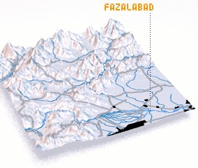 Places with similar names to Fazalābād, Pakistan ::
// Vāşelābād (IR)
// Vasīlābād (IR)
// Faisalābād (PK)
// Fazalābād (PK)
// Fazalābād (PK)
// Fāzalābād (PK)
// Fazal-i-Abad (PK)
// Fazilābād (PK)
// Fāzilābād (PK)
// Fazlābād (PK)
Disclaimer :: Information on this page comes without warranty of any kind |
||
|
Where is Fazalābād? Elevation and coordinates ::
Latitude (lat): 34°8'13"N Longitude (lon): 71°46'13"E
Elevation (approx.): 300m (map arrows pan, magnifying glasses zoom) |
||
|
Visiting Fazalābād? Hotel/Accommodation ::
Book a hotel in Fazalābād Travel Guide ::
Buy a travel guide for Pakistan rental cars ::
car rental offers GPS waypoint ::
download a GPX waypoint (PoI) of Fazalābād for your GPS receiver
|
||