|
search place name
|
||
Gegan (Pakistan)Gegan is a town in Pakistan. An overview map of the region around Gegan is displayed below.
regional and 3d topo map of Gegan, Pakistan ::

Gegan airports ::
The nearest airport is RAZ - Rawala Kot Rawalakot, located 92.7 km north of Gegan.
Other airports nearby include ISB - Islamabad Chaklala (95.2 km north west), IXJ - Jammu (101.1 km east), SXR - Srinagar (139.2 km north east), MFG - Muzaffarabad (149.9 km north), Nearby towns ::
Muftiān (1.0km north east) //
Khokar (1.0km south west) //
Raiān (1.0km west) //
Sahawa (1.3km north) //
Gorsiān (1.4km north east) //
Dhudiān (1.3km west) //
Guriān (1.3km west) //
Sagar (1.3km west) //
Kālas (1.9km north) //
Naugraon (1.8km west) //
Juiān (2.1km west) //
Ahbdupur (2.5km north) //
Rahmānpur (2.6km south east) //
Chak Dilu (2.7km north west) //
Mumbar (3.2km south) //
Mughal (2.9km west) //
Nagiāl (3.1km north west) //
Rāipur (3.3km south west) //
Shakrila (3.4km south) //
Goriān (3.4km south) //
Athār (3.4km south) //
Chak Langa (3.3km north west) //
Ghasītpurāwān (3.6km south) //
Bens (3.5km north west) //
Ghāsipur (3.6km north west) //
Saādatpur (4.0km south east) //
Bhumle (4.0km south east) //
Bhagoshāhpur (4.0km south east) //
Barsāli (3.6km west) //
[all distances 'as the bird flies' and approximate] 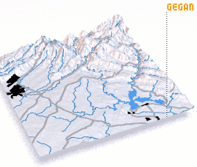 Places with similar names to Gegan, Pakistan ::
Disclaimer :: Information on this page comes without warranty of any kind |
||
|
Where is Gegan? Elevation and coordinates ::
Latitude (lat): 33°0'50"N Longitude (lon): 73°49'40"E
Elevation (approx.): 235m (map arrows pan, magnifying glasses zoom) |
||
|
Visiting Gegan? Hotel/Accommodation ::
Book a hotel in Gegan Travel Guide ::
Buy a travel guide for Pakistan rental cars ::
car rental offers GPS waypoint ::
download a GPX waypoint (PoI) of Gegan for your GPS receiver
|
||