|
search place name
|
||
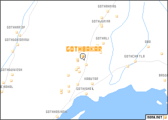
Goth Bakar (Balochistān, Pakistan)Goth Bakar is a town in the Balochistān region of Pakistan. An overview map of the region around Goth Bakar is displayed below.
regional and 3d topo map of Goth Bakar, Pakistan ::
Goth Bakar airports ::
The nearest airport is KHI - Karachi Jinnah Intl, located 128.5 km south east of Goth Bakar.
Other airports nearby include MJD - Moenjodaro (266.9 km north east), Nearby towns ::
Goth Sumar (1.2km south east) //
Goth Eisa (1.3km west) //
Goth Lawang (1.4km west) //
Goth Ramzān (2.0km south west) //
Goth Rahim Khan (2.1km north west) //
Goth Bahādur (2.6km south west) //
Goth Mūsa (2.8km south) //
Goth Allāh Bochālo (3.5km north east) //
Goth Ayūb Shikāri (3.5km north west) //
Goth Abbās (3.7km north east) //
Goth Allana (4.3km north east) //
Goth Dodo (4.7km south west) //
Kabūtar (5.5km south) //
Goth Usmān (5.5km south) //
Goth Ali (5.4km north east) //
Goth Mūsa (6.6km south west) //
Goth Ismāil (7.6km south) //
Goth Ghatta (7.6km south west) //
Goth Arif (8.2km south west) //
Goth Jumma (8.4km north east) //
Goth Hāshim (8.6km north east) //
Goth Ghulam Qādir (8.6km south west) //
[all distances 'as the bird flies' and approximate]  Places with similar names to Goth Bakar, Pakistan :: Disclaimer :: Information on this page comes without warranty of any kind |
||
|
Where is Goth Bakar? Elevation and coordinates ::
Latitude (lat): 25°40'25"N Longitude (lon): 66°12'15"E
Elevation (approx.): 13m (map arrows pan, magnifying glasses zoom) |
||
|
Visiting Goth Bakar? Hotel/Accommodation ::
Book a hotel in Goth Bakar Travel Guide ::
Buy a travel guide for Pakistan rental cars ::
car rental offers GPS waypoint ::
download a GPX waypoint (PoI) of Goth Bakar for your GPS receiver
|
||