|
search place name
|
||
Goth Bhand Hamza Khān (Balochistān, Pakistan)Goth Bhand Hamza Khān is a town in the Balochistān region of Pakistan. An overview map of the region around Goth Bhand Hamza Khān is displayed below.
regional and 3d topo map of Goth Bhand Hamza Khān, Pakistan ::

Goth Bhand Hamza Khān airports ::
The nearest airport is SUL - Sui, located 145.9 km east of Goth Bhand Hamza Khān.
Other airports nearby include UET - Quetta (158.7 km north west), SKZ - Sukkur (175.5 km south east), MJD - Moenjodaro (188.9 km south), Nearby towns ::
Hāji Jāh (1.7km north west) //
Goth Bhand Muhammad Ashrft (2.4km west) //
Sher Khān (3.2km north east) //
Jalāl Khān (3.6km north) //
Sad Bela (4.0km north west) //
Jamrah (4.6km north) //
Arāīn (4.2km south west) //
Goth Jhanda (4.9km north) //
Rehanzai Kalān (5.5km north) //
Rehānzai (6.3km north) //
Lālu (7.3km north) //
Hājijāh (8.5km north east) //
Goth Jhanda (7.9km east) //
Goth Methu (8.2km north west) //
Bhāg (8.5km north east) //
Goth Ali Wāli (9.0km north west) //
[all distances 'as the bird flies' and approximate] 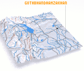 Places with similar names to Goth Bhand Hamza Khān, Pakistan :: Disclaimer :: Information on this page comes without warranty of any kind |
||
|
Where is Goth Bhand Hamza Khān? Elevation and coordinates ::
Latitude (lat): 29°0'5"N Longitude (lon): 67°44'15"E
Elevation (approx.): 91m (map arrows pan, magnifying glasses zoom) |
||
|
Visiting Goth Bhand Hamza Khān? Hotel/Accommodation ::
Book a hotel in Goth Bhand Hamza Khān Travel Guide ::
Buy a travel guide for Pakistan rental cars ::
car rental offers GPS waypoint ::
download a GPX waypoint (PoI) of Goth Bhand Hamza Khān for your GPS receiver
|
||