|
search place name
|
||
Jandarān (North-West Frontier, Pakistan)Jandarān is a town in the North-West Frontier region of Pakistan. An overview map of the region around Jandarān is displayed below.
regional and 3d topo map of Jandarān, Pakistan ::

Jandarān airports ::
The nearest airport is MFG - Muzaffarabad, located 33.0 km east of Jandarān.
Other airports nearby include ISB - Islamabad Chaklala (74.7 km south), RAZ - Rawala Kot Rawalakot (76.8 km south east), SDT - Saidu Sharif (93.9 km north west), SXR - Srinagar (153.0 km east), Nearby towns ::
Phuto di Gali (0.7km south west) //
Nimli (1.3km east) //
Gūjarān (1.4km west) //
Ogra (1.6km north east) //
Kot (2.0km south) //
Kaju (1.9km north west) //
Mohāiyān (2.3km south east) //
Shahelia (2.6km north) //
Pakhwāl (2.2km west) //
Kalial (2.6km north east) //
Pulāthai (2.6km south west) //
Jallo (3.1km north) //
Sunāri (3.0km south west) //
Danna (2.7km east) //
Kutaira (3.0km south west) //
Kharāl (3.3km south east) //
Pulasahri (3.2km east) //
Rattiān (3.4km south east) //
Rihār (3.6km south east) //
Karer (4.4km south) //
Dāngari (4.2km north east) //
Janjkiāri (4.3km south west) //
Goldheri (3.7km east) //
Bihāli (4.4km south) //
Balhag Utli (3.8km west) //
Pakhwāl (4.1km north east) //
Chhari di Kassi (4.0km east) //
Charāch (4.8km south) //
Ganda (4.9km north) //
[all distances 'as the bird flies' and approximate] 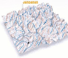 Places with similar names to Jandarān, Pakistan ::
Disclaimer :: Information on this page comes without warranty of any kind |
||
|
Where is Jandarān? Elevation and coordinates ::
Latitude (lat): 34°17'20"N Longitude (lon): 73°9'20"E
Elevation (approx.): 1151m (map arrows pan, magnifying glasses zoom) |
||
|
Visiting Jandarān? Hotel/Accommodation ::
Book a hotel in Jandarān Travel Guide ::
Buy a travel guide for Pakistan rental cars ::
car rental offers GPS waypoint ::
download a GPX waypoint (PoI) of Jandarān for your GPS receiver
|
||