|
search place name
|
||
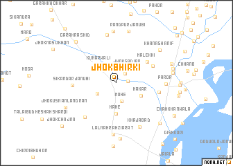
Jhok Bhirki (North-West Frontier, Pakistan)Jhok Bhirki is a town in the North-West Frontier region of Pakistan. An overview map of the region around Jhok Bhirki is displayed below.
regional and 3d topo map of Jhok Bhirki, Pakistan ::
Jhok Bhirki airports ::
The nearest airport is PZH - Zhob, located 118.4 km west of Jhok Bhirki.
Other airports nearby include MUX - Multan Intl (165.7 km south east), Nearby towns ::
Jhok Māchhi (1.6km east) //
Jhok Jhundirān (1.9km north east) //
Jhok Mamdu (2.7km north) //
Jhok Gādian (2.8km north east) //
Mahe (3.1km south) //
Basti Durwaliān (3.1km south west) //
Kumārwāli (3.8km north west) //
Makar (3.9km south east) //
Mahe (5.0km south) //
Malekhi (5.4km north east) //
Jhok Gaunsar (5.7km north east) //
Sikandar Janubi (6.0km west) //
Jhok Wazīr Korai (6.1km east) //
Basti Khojhiāwāli (7.0km south west) //
Adil Sipra (7.9km north) //
Paroa (6.8km east) //
Khājābād (7.8km south east) //
Adil Sipra Khurd (8.3km north) //
Lāl Māhrāh Ziārat (8.3km south) //
Rangpur Janubi (8.4km north) //
Khāna Sharīf (8.0km north east) //
Jhok Usmān Langrān (8.0km south west) //
Garah Rashīd (8.6km north west) //
Chāh Sheikhwāra (8.2km east) //
Māhrāh (8.8km south east) //
Jhok Chajra (10.2km south west) //
Garah Muhammad Amin (10.2km south west) //
Garah Baluch Kāwānwāla (11.3km north west) //
[all distances 'as the bird flies' and approximate]  Places with similar names to Jhok Bhirki, Pakistan :: Disclaimer :: Information on this page comes without warranty of any kind |
||
|
Where is Jhok Bhirki? Elevation and coordinates ::
Latitude (lat): 31°33'30"N Longitude (lon): 70°41'15"E
Elevation (approx.): 170m (map arrows pan, magnifying glasses zoom) |
||
|
Visiting Jhok Bhirki? Hotel/Accommodation ::
Book a hotel in Jhok Bhirki Travel Guide ::
Buy a travel guide for Pakistan rental cars ::
car rental offers GPS waypoint ::
download a GPX waypoint (PoI) of Jhok Bhirki for your GPS receiver
|
||