|
search place name
|
||
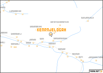
Kenrnjelogāh (Pakistan)Kenrnjelogāh is a town in Pakistan. An overview map of the region around Kenrnjelogāh is displayed below.
regional and 3d topo map of Kenrnjelogāh, Pakistan ::
Kenrnjelogāh airports ::
The nearest airport is SXR - Srinagar, located 93.3 km south of Kenrnjelogāh.
Other airports nearby include MFG - Muzaffarabad (113.0 km south west), GIL - Gilgit (124.8 km north), RAZ - Rawala Kot Rawalakot (129.9 km south west), ISB - Islamabad Chaklala (191.7 km south west), Nearby towns ::
Fagīr-e-Banar (1.5km north east) //
Dāki Baihk (1.6km south) //
Gaiwāla Pāthri (2.0km north east) //
Jastarubaha (3.0km north east) //
Marnāt (3.7km south) //
Marnāt (3.8km south) //
Sardāri Baihk (3.3km south east) //
Seri (3.4km south west) //
Burjanwāla (3.8km north east) //
Hayāt Khān Pathri (4.9km north east) //
Dadār Baihk (5.2km north west) //
Folowai (5.6km south west) //
Sardār (6.6km south east) //
Jānwai (5.9km south west) //
Shundās (7.7km south east) //
Doga (7.5km south west) //
Halmat (8.7km south east) //
[all distances 'as the bird flies' and approximate] 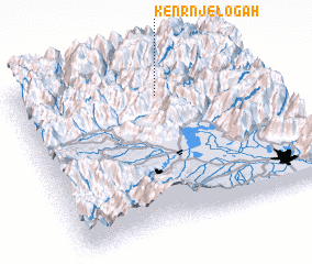 Places with similar names to Kenrnjelogāh, Pakistan :: Disclaimer :: Information on this page comes without warranty of any kind |
||
|
Where is Kenrnjelogāh? Elevation and coordinates ::
Latitude (lat): 34°48'55"N Longitude (lon): 74°35'50"E
Elevation (approx.): 2702m (map arrows pan, magnifying glasses zoom) |
||
|
Visiting Kenrnjelogāh? Hotel/Accommodation ::
Book a hotel in Kenrnjelogāh Travel Guide ::
Buy a travel guide for Pakistan rental cars ::
car rental offers GPS waypoint ::
download a GPX waypoint (PoI) of Kenrnjelogāh for your GPS receiver
|
||