|
search place name
|
||
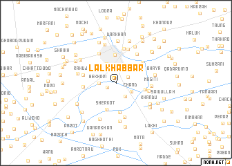
Lāl Khabbar (Sind, Pakistan)Lāl Khabbar is a town in the Sind region of Pakistan. An overview map of the region around Lāl Khabbar is displayed below.
regional and 3d topo map of Lāl Khabbar, Pakistan ::
Lāl Khabbar airports ::
The nearest airport is SKZ - Sukkur, located 26.4 km south east of Lāl Khabbar.
Other airports nearby include MJD - Moenjodaro (81.9 km south west), SUL - Sui (95.5 km north east), RYK - Rahim Yar Khan Sheikh Zayed (168.3 km east), WNS - Nawabshah (190.4 km south), Nearby towns ::
Haina (1.5km south west) //
Jāno (2.0km north east) //
Jāmra (2.6km south east) //
Bekhāri (2.5km west) //
Chānd (2.6km south east) //
Shikārpur (3.4km north west) //
Meharpur (4.5km north) //
Sherkot (4.5km south) //
Bhāi Khān (4.8km south) //
Boja Nāpar (4.4km east) //
Māri (4.7km west) //
Garhi Halīm (4.8km east) //
Rahūja (4.8km west) //
Phulpota (5.0km north east) //
Lāra (5.4km north west) //
Amza (5.7km north) //
Habībkot (5.7km south) //
Masiti (5.1km east) //
Khokhar (5.5km north east) //
Khair Muhammad Brohi (5.7km north) //
Tinda (6.2km south) //
Rahri (5.7km west) //
Tindo Bahār (6.3km south) //
Ali Baig Chāndio (6.4km north) //
Bhaya (5.7km east) //
Khandu (6.0km south east) //
Jam (6.5km north east) //
Darkhan (6.8km north) //
Bed (6.3km north west) //
[all distances 'as the bird flies' and approximate]  Places with similar names to Lāl Khabbar, Pakistan :: Disclaimer :: Information on this page comes without warranty of any kind |
||
|
Where is Lāl Khabbar? Elevation and coordinates ::
Latitude (lat): 27°55'20"N Longitude (lon): 68°38'50"E
Elevation (approx.): 67m (map arrows pan, magnifying glasses zoom) |
||
|
Visiting Lāl Khabbar? Hotel/Accommodation ::
Book a hotel in Lāl Khabbar Travel Guide ::
Buy a travel guide for Pakistan rental cars ::
car rental offers GPS waypoint ::
download a GPX waypoint (PoI) of Lāl Khabbar for your GPS receiver
|
||