|
search place name
|
||
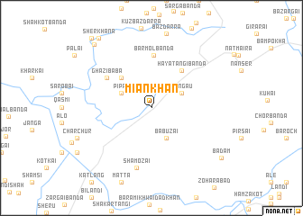
Miān Khān (North-West Frontier, Pakistan)Miān Khān is a town in the North-West Frontier region of Pakistan. An overview map of the region around Miān Khān is displayed below.
regional and 3d topo map of Miān Khān, Pakistan ::
Miān Khān airports ::
The nearest airport is SDT - Saidu Sharif, located 44.4 km north east of Miān Khān.
Other airports nearby include PEW - Peshawar Intl (77.4 km south west), MFG - Muzaffarabad (125.5 km east), ISB - Islamabad Chaklala (127.4 km south east), JAA - Jalalabad (151.9 km west), Nearby towns ::
Sangāu (3.6km north east) //
Bābūzai (4.0km south) //
Pīpal (3.6km north west) //
Khūi Barmol (4.8km north west) //
Haya Tangi Bānda (5.6km north east) //
Barmol Bānda (6.5km north) //
Ghāzi Bāba (5.9km north west) //
Shamozai (7.6km south) //
Zormandai (9.8km north west) //
Bādām (9.4km south east) //
Sher Khāna (10.2km north west) //
Jalālpur (10.6km north west) //
[all distances 'as the bird flies' and approximate] 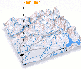 Places with similar names to Miān Khān, Pakistan ::
Disclaimer :: Information on this page comes without warranty of any kind |
||
|
Where is Miān Khān? Elevation and coordinates ::
Latitude (lat): 34°27'0"N Longitude (lon): 72°9'0"E
Elevation (approx.): 487m (map arrows pan, magnifying glasses zoom) |
||
|
Visiting Miān Khān? Hotel/Accommodation ::
Book a hotel in Miān Khān Travel Guide ::
Buy a travel guide for Pakistan rental cars ::
car rental offers GPS waypoint ::
download a GPX waypoint (PoI) of Miān Khān for your GPS receiver
|
||