|
search place name
|
||
Muhammad Hasan Solangi (Sind, Pakistan)Muhammad Hasan Solangi is a town in the Sind region of Pakistan. An overview map of the region around Muhammad Hasan Solangi is displayed below.
regional and 3d topo map of Muhammad Hasan Solangi, Pakistan ::

Muhammad Hasan Solangi airports ::
The nearest airport is MJD - Moenjodaro, located 33.5 km north of Muhammad Hasan Solangi.
Other airports nearby include WNS - Nawabshah (92.9 km south), SKZ - Sukkur (98.4 km north east), SUL - Sui (204.6 km north east), Nearby towns ::
Goth Sūbedār (0.0km north) //
Goth Dāim Solangi (0.6km south) //
Goth Morāt (0.7km north east) //
Goth Sher Muhammad Baloch (0.8km north east) //
Goth Hāji Muharram Kalhoro (0.9km south) //
Goth Pīrzada (1.0km south east) //
Goth Adar Panhwer (1.3km south) //
Goth Arāzi Kalhoro (1.2km north east) //
Goth Hayāt Siāl (1.2km north east) //
Goth Kand (1.4km north west) //
Goth Jān Muhammad Rājpur (1.6km south) //
Goth Detha (1.5km north west) //
Goth Chutta Bhatti (1.5km west) //
Goth Mitha Sial (1.7km south west) //
Goth Qādir Mehtra (2.0km south) //
Goth Bakhtāwarpur (2.1km south east) //
Goth Nūr Muhammad Rind Baloch (2.1km east) //
Goth Ali Muhammad Dasti (2.6km south) //
Goth Ummīd Ali Jamāl (2.6km north) //
Goth Somar Dhāri (2.6km south west) //
Kandhar (2.7km south east) //
Goth Umar Mahesar (2.7km south west) //
Goth Somār Chanher (2.7km north west) //
Goth Qāsim Chinna (2.8km north west) //
Goth Khamiso Kalhoro (3.0km north) //
Goth Darpāli (2.8km east) //
Goth Ghāzi Khān Gopāng (3.1km south east) //
Goth Abdul Majid Mahesar (3.2km south west) //
Goth Ūdal Sehto (3.4km south) //
[all distances 'as the bird flies' and approximate] 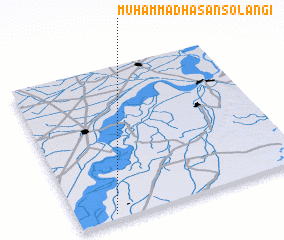 Places with similar names to Muhammad Hasan Solangi, Pakistan :: Disclaimer :: Information on this page comes without warranty of any kind |
||
|
Where is Muhammad Hasan Solangi? Elevation and coordinates ::
Latitude (lat): 27°2'0"N Longitude (lon): 68°9'50"E
Elevation (approx.): 47m (map arrows pan, magnifying glasses zoom) |
||
|
Visiting Muhammad Hasan Solangi? Hotel/Accommodation ::
Book a hotel in Muhammad Hasan Solangi Travel Guide ::
Buy a travel guide for Pakistan rental cars ::
car rental offers GPS waypoint ::
download a GPX waypoint (PoI) of Muhammad Hasan Solangi for your GPS receiver
|
||