|
search place name
|
||
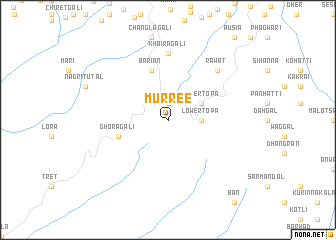
Murree (Punjab, Pakistan)Murree is a town in the Punjab region of Pakistan. An overview map of the region around Murree is displayed below.
regional and 3d topo map of Murree, Pakistan ::
Murree airports ::
The nearest airport is RAZ - Rawala Kot Rawalakot, located 37.3 km east of Murree.
Other airports nearby include ISB - Islamabad Chaklala (42.0 km south west), MFG - Muzaffarabad (49.7 km north), SXR - Srinagar (127.4 km east), SDT - Saidu Sharif (139.8 km north west), Nearby towns ::
Kuldanna (1.9km north) //
Lower Topa (3.1km east) //
Upper Topa (3.6km north east) //
Bāriān (5.8km north) //
Ghora Gali (5.0km west) //
Khaira Gali (7.4km north) //
Rāwāt (7.2km north east) //
[all distances 'as the bird flies' and approximate] 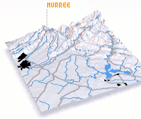 Places with similar names to Murree, Pakistan ::
Disclaimer :: Information on this page comes without warranty of any kind |
||
|
Where is Murree? Elevation and coordinates ::
Latitude (lat): 33°54'0"N Longitude (lon): 73°24'0"E
Elevation (approx.): 1898m (map arrows pan, magnifying glasses zoom) |
||
|
Visiting Murree? Hotel/Accommodation ::
Book a hotel in Murree Travel Guide ::
Buy a travel guide for Pakistan rental cars ::
car rental offers GPS waypoint ::
download a GPX waypoint (PoI) of Murree for your GPS receiver
|
||