|
search place name
|
||
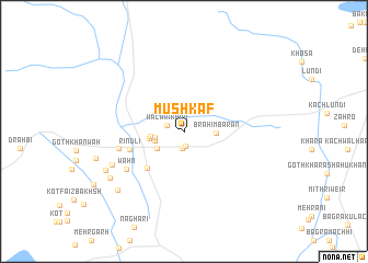
Mushkāf (Balochistān, Pakistan)Mushkāf is a town in the Balochistān region of Pakistan. An overview map of the region around Mushkāf is displayed below.
regional and 3d topo map of Mushkāf, Pakistan ::
Mushkāf airports ::
The nearest airport is UET - Quetta, located 110.1 km north west of Mushkāf.
Other airports nearby include SUL - Sui (173.6 km south east), SKZ - Sukkur (224.9 km south east), PZH - Zhob (267.7 km north east), Nearby towns ::
Fazilābād (1.6km south) //
Dur Khān (1.7km south) //
Wālāri Khān (1.6km north west) //
Goth Gichki (2.6km west) //
Goth Ghulam Nabi (2.7km west) //
Brāhim Bārān (2.8km east) //
Goth Mehrullāh (3.0km south west) //
Goth Umar (3.0km west) //
Goth Mahmood Khān (3.2km west) //
Dādhar (4.9km south west) //
Rindli (5.2km west) //
Kili Sātakzai (6.0km west) //
Wāhn (6.4km south west) //
Goth Ghulām Bulak (7.2km south west) //
Soni Jalambāni (8.1km south west) //
Goth Chotāi (8.1km south west) //
Charkhi (8.4km south west) //
[all distances 'as the bird flies' and approximate] 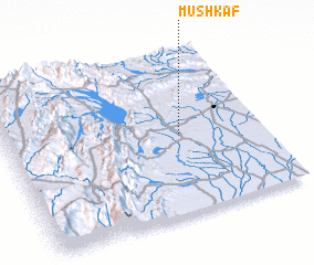 Places with similar names to Mushkāf, Pakistan ::
Disclaimer :: Information on this page comes without warranty of any kind |
||
|
Where is Mushkāf? Elevation and coordinates ::
Latitude (lat): 29°30'0"N Longitude (lon): 67°41'0"E
Elevation (approx.): 144m (map arrows pan, magnifying glasses zoom) |
||
|
Visiting Mushkāf? Hotel/Accommodation ::
Book a hotel in Mushkāf Travel Guide ::
Buy a travel guide for Pakistan rental cars ::
car rental offers GPS waypoint ::
download a GPX waypoint (PoI) of Mushkāf for your GPS receiver
|
||