|
search place name
|
||
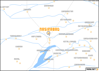
Nāsirabād (North-West Frontier, Pakistan)Nāsirabād is a town in the North-West Frontier region of Pakistan. An overview map of the region around Nāsirabād is displayed below.
regional and 3d topo map of Nāsirabād, Pakistan ::
Nāsirabād airports ::
The nearest airport is PZH - Zhob, located 93.5 km south west of Nāsirabād.
Other airports nearby include MUX - Multan Intl (200.4 km south east), Nearby towns ::
New Darāban (1.3km south) //
Darāban Kalān (1.9km south) //
Darāban Khurd (2.8km south) //
Kot Lālu (3.6km north west) //
Hafizābād (4.4km west) //
Pīr Panjan Shāh (5.5km east) //
Maskota Basti (6.8km south) //
Kot Isa Khan (7.3km north east) //
Mūsezai (8.1km south) //
Kot Allāh Dad (7.3km south east) //
Kirri Mauladād Miān Khel (8.6km south east) //
Gara Mastān (10.1km north east) //
[all distances 'as the bird flies' and approximate] 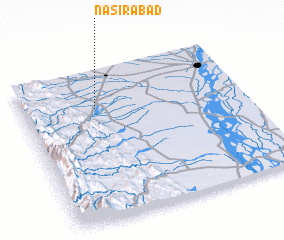 Places with similar names to Nāsirabād, Pakistan ::
Disclaimer :: Information on this page comes without warranty of any kind |
||
|
Where is Nāsirabād? Elevation and coordinates ::
Latitude (lat): 31°45'4"N Longitude (lon): 70°20'8"E
Elevation (approx.): 235m (map arrows pan, magnifying glasses zoom) |
||
|
Visiting Nāsirabād? Hotel/Accommodation ::
Book a hotel in Nāsirabād Travel Guide ::
Buy a travel guide for Pakistan rental cars ::
car rental offers GPS waypoint ::
download a GPX waypoint (PoI) of Nāsirabād for your GPS receiver
|
||