|
search place name
|
||
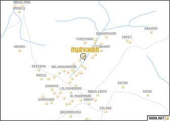
Nūr Khān (Balochistān, Pakistan)Nūr Khān is a town in the Balochistān region of Pakistan. An overview map of the region around Nūr Khān is displayed below.
regional and 3d topo map of Nūr Khān, Pakistan ::
Nūr Khān airports ::
The nearest airport is UET - Quetta, located 31.3 km north west of Nūr Khān.
Other airports nearby include KDH - Kandahar (204.8 km north west), Nearby towns ::
Jhanda Khān (0.9km west) //
Rasūl Bakhsh (1.3km south west) //
Karīm Bakhsh (1.7km south) //
Dīnu (1.6km north east) //
Arz Muhammad (2.2km north) //
Shāh Bakhsh (2.3km north east) //
Jumma Khān (2.3km south west) //
Lāl Muhammad (2.9km south) //
Faiz Muhammad (2.9km south) //
Sherdil (3.3km south west) //
Shāh Bakhsh (3.2km south west) //
Fīroz Khān (3.9km north) //
Muhammad Qāsim (3.8km south west) //
Surāb Khān (3.7km north east) //
Mirza Khān (4.3km north east) //
Mazāri (4.1km south west) //
Abdullāh (4.8km south west) //
Nūr Dīn (4.8km north east) //
Sher Muhammad (5.0km north east) //
Sālih Muhammad (4.6km south west) //
Jamālān (5.8km south) //
Saīd Ullah (5.8km south west) //
Muhammad Amin (5.6km south west) //
Gauhar Khān (6.5km north east) //
Imām Bakhsh (7.0km south west) //
Lāl Muhammad (7.6km south) //
Abdul Karīm (8.1km south) //
Ali Muhammad (8.8km south) //
Muhammad Khān (8.5km south west) //
[all distances 'as the bird flies' and approximate]  Places with similar names to Nūr Khān, Pakistan ::
Disclaimer :: Information on this page comes without warranty of any kind |
||
|
Where is Nūr Khān? Elevation and coordinates ::
Latitude (lat): 30°0'10"N Longitude (lon): 67°5'30"E
Elevation (approx.): 1841m (map arrows pan, magnifying glasses zoom) |
||
|
Visiting Nūr Khān? Hotel/Accommodation ::
Book a hotel in Nūr Khān Travel Guide ::
Buy a travel guide for Pakistan rental cars ::
car rental offers GPS waypoint ::
download a GPX waypoint (PoI) of Nūr Khān for your GPS receiver
|
||