|
search place name
|
||
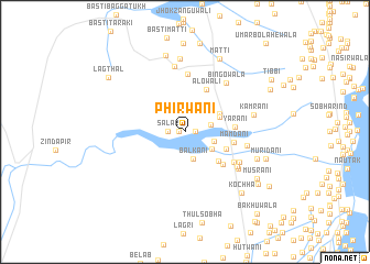
Phirwāni (Punjab, Pakistan)Phirwāni is a town in the Punjab region of Pakistan. An overview map of the region around Phirwāni is displayed below.
regional and 3d topo map of Phirwāni, Pakistan ::
Phirwāni airports ::
The nearest airport is MUX - Multan Intl, located 84.2 km east of Phirwāni.
Other airports nearby include PZH - Zhob (148.3 km north west), SUL - Sui (240.6 km south west), Nearby towns ::
Ghulām Husain (0.5km west) //
Jhok Fāzil (0.9km east) //
Salār (1.5km west) //
Jagwāni (2.4km east) //
Balkāni (2.8km south) //
Khosa (2.7km east) //
Gādi (2.9km south east) //
Moryāni (3.4km north east) //
Jamālpur (3.6km north east) //
Jangwāni (4.1km south east) //
Nathwāni (4.0km south east) //
Alowāli (4.7km north east) //
Gādi (4.6km south east) //
Mamdāni (4.4km east) //
Yārāni (4.4km east) //
Barnāni (5.3km south east) //
Kaleri (5.9km north) //
Qasmāni (5.7km south east) //
Hota Hatwāni (5.8km south east) //
Bingowāla (6.1km north east) //
Jamwāni (5.6km east) //
Bahādur Shāh (6.0km south east) //
Lākhi (6.7km north) //
Kamrāni (6.2km east) //
Basti Gharjal (7.4km north) //
Gurchāni (6.8km south east) //
Jhok Allāh Bakhshwāli (7.9km north) //
Matti (8.0km north) //
Kochha (7.9km south east) //
[all distances 'as the bird flies' and approximate]  Places with similar names to Phirwāni, Pakistan ::
Disclaimer :: Information on this page comes without warranty of any kind |
||
|
Where is Phirwāni? Elevation and coordinates ::
Latitude (lat): 30°26'0"N Longitude (lon): 70°35'5"E
Elevation (approx.): 192m (map arrows pan, magnifying glasses zoom) |
||
|
Visiting Phirwāni? Hotel/Accommodation ::
Book a hotel in Phirwāni Travel Guide ::
Buy a travel guide for Pakistan rental cars ::
car rental offers GPS waypoint ::
download a GPX waypoint (PoI) of Phirwāni for your GPS receiver
|
||