|
search place name
|
||
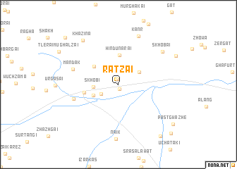
Rātzai (Balochistān, Pakistan)Rātzai is a town in the Balochistān region of Pakistan. An overview map of the region around Rātzai is displayed below.
regional and 3d topo map of Rātzai, Pakistan ::
Rātzai airports ::
The nearest airport is UET - Quetta, located 104.3 km south west of Rātzai.
Other airports nearby include PZH - Zhob (170.0 km east), KDH - Kandahar (199.3 km west), Nearby towns ::
Loe Kārez (0.7km south) //
Sām Khel (0.8km north) //
Mangūra (2.8km south west) //
Khānai (3.5km north east) //
Skhobi (3.4km west) //
Parkanda (3.8km south west) //
Hindu Narai (4.6km north) //
Manzghalai (4.3km north west) //
Muslimbāgh (4.8km west) //
Kārezgi (6.5km west) //
Mandak (6.6km west) //
Kānr (8.1km north) //
Nāik (8.7km south) //
Skhobai (7.9km north east) //
Khazina (8.5km north west) //
Romezh (10.0km south east) //
Past Gwazhe (9.7km south east) //
Malguzār (10.3km north west) //
Kharāba (10.5km south east) //
[all distances 'as the bird flies' and approximate]  Places with similar names to Rātzai, Pakistan ::
Disclaimer :: Information on this page comes without warranty of any kind |
||
|
Where is Rātzai? Elevation and coordinates ::
Latitude (lat): 30°50'11"N Longitude (lon): 67°47'19"E
Elevation (approx.): 1754m (map arrows pan, magnifying glasses zoom) |
||
|
Visiting Rātzai? Hotel/Accommodation ::
Book a hotel in Rātzai Travel Guide ::
Buy a travel guide for Pakistan rental cars ::
car rental offers GPS waypoint ::
download a GPX waypoint (PoI) of Rātzai for your GPS receiver
|
||