|
search place name
|
||
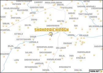
Shahr Rāi Chirāgh (Punjab, Pakistan)Shahr Rāi Chirāgh is a town in the Punjab region of Pakistan. An overview map of the region around Shahr Rāi Chirāgh is displayed below.
regional and 3d topo map of Shahr Rāi Chirāgh, Pakistan ::
Shahr Rāi Chirāgh airports ::
The nearest airport is ISB - Islamabad Chaklala, located 48.9 km east of Shahr Rāi Chirāgh.
Other airports nearby include PEW - Peshawar Intl (115.6 km north west), RAZ - Rawala Kot Rawalakot (118.6 km east), MFG - Muzaffarabad (127.2 km north east), SDT - Saidu Sharif (149.7 km north), Nearby towns ::
Shahr Rāi Bahādur (1.1km south west) //
Shahr Rāi Sādullāh (1.2km north west) //
Sheikh Hājiwāla (2.6km north east) //
Dhok Rai Neka (3.1km north) //
Tājābāra (3.5km north east) //
Mondanwāli Dhok (5.1km south west) //
Hastāl (5.6km north east) //
Burj (5.9km north) //
Dhok Kirān Wāli (5.4km north west) //
Kharāla Jhangiānwāla (6.2km north) //
Gali Jāgir (5.9km south east) //
Ali Muhammad (6.4km south) //
Nakodar (6.0km south east) //
Gadda (5.7km west) //
Ismāil (6.2km south west) //
Māhjia (5.8km east) //
Kharāla Khurd (6.9km north) //
Lāniwāla (6.1km south west) //
Sheikh Sābir (7.0km south) //
Jaspāl (6.0km east) //
Dhok Saiyidān (6.8km north east) //
Kharāla Kalān (7.9km north) //
Dhok Maiki (7.8km south west) //
Garhu (7.4km north west) //
Malāl (8.6km south) //
Dhok Kamāl Shāh (9.0km north) //
Aruria (7.7km east) //
Guliāl (7.8km north west) //
Pind Fateh (7.8km south east) //
[all distances 'as the bird flies' and approximate]  Places with similar names to Shahr Rāi Chirāgh, Pakistan ::
// Cherichira (TN)
// Churashur (RU)
// Churashur (RU)
// Cher Cher (IR)
// Chercher (IR)
// Cher Cherā (IR)
// Chūrchūrī (IR)
// Char Charia (BD)
// Shar-Shar (UZ)
// Shar-Shar (UZ)
Disclaimer :: Information on this page comes without warranty of any kind |
||
|
Where is Shahr Rāi Chirāgh? Elevation and coordinates ::
Latitude (lat): 33°28'45"N Longitude (lon): 72°35'56"E
Elevation (approx.): 462m (map arrows pan, magnifying glasses zoom) |
||
|
Visiting Shahr Rāi Chirāgh? Hotel/Accommodation ::
Book a hotel in Shahr Rāi Chirāgh Travel Guide ::
Buy a travel guide for Pakistan rental cars ::
car rental offers GPS waypoint ::
download a GPX waypoint (PoI) of Shahr Rāi Chirāgh for your GPS receiver
|
||