|
search place name
|
||
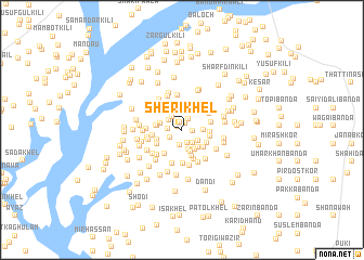
Sheri Khel (North-West Frontier, Pakistan)Sheri Khel is a town in the North-West Frontier region of Pakistan. An overview map of the region around Sheri Khel is displayed below.
regional and 3d topo map of Sheri Khel, Pakistan ::
Sheri Khel airports ::
The nearest airport is PEW - Peshawar Intl, located 126.8 km north east of Sheri Khel.
Other airports nearby include JAA - Jalalabad (164.2 km north), PZH - Zhob (225.1 km south west), KBL - Kabul Intl (238.3 km north west), SDT - Saidu Sharif (244.1 km north east), Nearby towns ::
Kotka Ālam Gul (0.5km north west) //
Abu Samand Kalla (0.7km north east) //
Aimal Kalla (0.8km north) //
Bagar Khel (0.9km east) //
Miāngul Khel (1.1km north west) //
Hāji Bānda (1.2km north east) //
Agri Kalla (1.3km south west) //
Shāh Hussaln Kalla (1.4km south) //
Kamar Kalla (1.3km west) //
Bali Gul (1.6km south) //
Teli Kalla (1.5km north west) //
Kotka Juma Khān (1.5km north west) //
Mādi Khel (1.6km south east) //
Laparāi Kalla (1.8km south east) //
Ālam Sheri (2.1km north) //
Mushārab (2.1km south) //
Kotka Musharab (2.1km south) //
Nandar Kalla (1.8km east) //
Kotka Hāji Mīr Sardār (2.0km west) //
Miryān Kalla (2.3km north west) //
Sherai kalla (2.4km south) //
Ādam Kalla (2.3km south east) //
Zaki Khel (2.3km south east) //
Mandat Khān (2.2km west) //
Khalagdād Kalla (2.4km south west) //
Shāh Salīm Kalla (2.3km west) //
Akhundān (2.5km south east) //
Gula Khān (2.8km south) //
Laghraī Bānda (2.4km east) //
[all distances 'as the bird flies' and approximate] 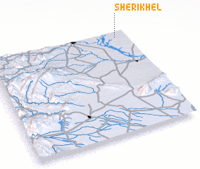 Places with similar names to Sheri Khel, Pakistan ::
// Shark Hole (PA)
// Charaikhola (BD)
// Charākhāli (BD)
// Chārakhāli (BD)
// Charakkhola (BD)
// Charkhāli (BD)
// Chirākhola (BD)
// Chorkhāli (BD)
// Chorkhāli (BD)
// Chorkhola (BD)
Disclaimer :: Information on this page comes without warranty of any kind |
||
|
Where is Sheri Khel? Elevation and coordinates ::
Latitude (lat): 32°57'46"N Longitude (lon): 70°55'33"E
Elevation (approx.): 395m (map arrows pan, magnifying glasses zoom) |
||
|
Visiting Sheri Khel? Hotel/Accommodation ::
Book a hotel in Sheri Khel Travel Guide ::
Buy a travel guide for Pakistan rental cars ::
car rental offers GPS waypoint ::
download a GPX waypoint (PoI) of Sheri Khel for your GPS receiver
|
||