|
search place name
|
||
Tauda Mela (Punjab, Pakistan)Tauda Mela is a town in the Punjab region of Pakistan. An overview map of the region around Tauda Mela is displayed below.
regional and 3d topo map of Tauda Mela, Pakistan ::

Tauda Mela airports ::
The nearest airport is PEW - Peshawar Intl, located 87.2 km north of Tauda Mela.
Other airports nearby include ISB - Islamabad Chaklala (130.1 km east), JAA - Jalalabad (174.8 km north west), SDT - Saidu Sharif (182.7 km north), MFG - Muzaffarabad (201.7 km north east), Nearby towns ::
Hir (1.0km east) //
Goah (2.5km south east) //
Zangora (2.7km east) //
Nirāwāla (3.3km east) //
Turakhel Mela (4.3km east) //
Malangi (5.5km north west) //
Niāz Gul (5.3km east) //
Paranga Bānda (7.5km south) //
Weli Mela (6.5km east) //
Mochi Kirri (6.9km east) //
Pāela (7.9km south east) //
Khanjar Dhok (8.4km south east) //
Zara Mela (9.0km south east) //
Subedār Dhok (9.7km south east) //
Nawl Nakka (9.9km south east) //
Barbunga (9.7km south east) //
Dakhni (10.3km north east) //
[all distances 'as the bird flies' and approximate] 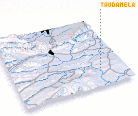 Places with similar names to Tauda Mela, Pakistan ::
Disclaimer :: Information on this page comes without warranty of any kind |
||
|
Where is Tauda Mela? Elevation and coordinates ::
Latitude (lat): 33°14'17"N Longitude (lon): 71°46'30"E
Elevation (approx.): 310m (map arrows pan, magnifying glasses zoom) |
||
|
Visiting Tauda Mela? Hotel/Accommodation ::
Book a hotel in Tauda Mela Travel Guide ::
Buy a travel guide for Pakistan rental cars ::
car rental offers GPS waypoint ::
download a GPX waypoint (PoI) of Tauda Mela for your GPS receiver
|
||