|
search place name
|
||
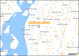
Umarwāli Bhān (Punjab, Pakistan)Umarwāli Bhān is a town in the Punjab region of Pakistan. An overview map of the region around Umarwāli Bhān is displayed below.
regional and 3d topo map of Umarwāli Bhān, Pakistan ::
Umarwāli Bhān airports ::
The nearest airport is PZH - Zhob, located 138.1 km west of Umarwāli Bhān.
Other airports nearby include MUX - Multan Intl (147.5 km south), Nearby towns ::
Mitthu (1.2km north) //
Kundrānwāli (2.4km north west) //
Dhāndla (2.2km east) //
Rathian (2.9km south) //
Bhir Rashīd Shāh (3.0km south) //
Basti Garāh (2.6km west) //
Bindu (3.3km north) //
Bakhtāwar Basti (2.9km east) //
Kathanwāla (3.6km south east) //
Basti Ali (3.3km west) //
Basti Hamza (3.9km south) //
Jhok Ata Muhammad (4.1km north east) //
Samtiah (4.8km south) //
Basti Lākha (4.2km east) //
Basti Haqi (5.0km north) //
Basti Jamāl (4.7km north east) //
Basti Dhol (5.3km north) //
Fateh Bhamb (4.6km east) //
Khyber (5.6km south) //
Saurah Kap (5.9km north east) //
Chāndia (6.0km north west) //
Basti Naurang (6.1km south east) //
Basti Mandrān (5.9km south east) //
Saiyidwāla (5.7km east) //
Kanju Khor (5.8km west) //
Basti Modānīwāli (6.6km north) //
Basti Atar Dhāndla (6.6km south east) //
Bharmi Nawāb Sāhib (6.9km north) //
Nahrewāla (6.1km east) //
[all distances 'as the bird flies' and approximate] 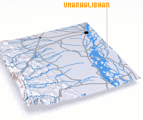 Places with similar names to Umarwāli Bhān, Pakistan :: Disclaimer :: Information on this page comes without warranty of any kind |
||
|
Where is Umarwāli Bhān? Elevation and coordinates ::
Latitude (lat): 31°27'35"N Longitude (lon): 70°54'40"E
Elevation (approx.): 164m (map arrows pan, magnifying glasses zoom) |
||
|
Visiting Umarwāli Bhān? Hotel/Accommodation ::
Book a hotel in Umarwāli Bhān Travel Guide ::
Buy a travel guide for Pakistan rental cars ::
car rental offers GPS waypoint ::
download a GPX waypoint (PoI) of Umarwāli Bhān for your GPS receiver
|
||