|
search place name
|
||
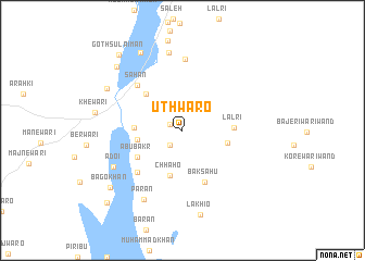
Uthwāro (Sind, Pakistan)Uthwāro is a town in the Sind region of Pakistan. An overview map of the region around Uthwāro is displayed below.
regional and 3d topo map of Uthwāro, Pakistan ::
Uthwāro airports ::
The nearest airport is WNS - Nawabshah, located 68.7 km south west of Uthwāro.
Other airports nearby include MJD - Moenjodaro (115.4 km north west), SKZ - Sukkur (127.1 km north), BDN - Talhar (193.3 km south), JSA - Jaisalmer (193.8 km east), Nearby towns ::
Baroi (1.3km north west) //
Sadīqwāri (1.9km south west) //
Pirbalo (4.2km west) //
Chhaho (4.8km south) //
Kakranwāro (4.3km east) //
Jiona Faqīr (4.4km west) //
Harūn (5.0km north west) //
Lālri (4.7km east) //
Abubakr (5.0km south west) //
Baksāhu (5.6km south) //
Khair Muhammad (6.0km south west) //
Sahan (6.2km north west) //
Ibrāhim Shāh (7.3km north) //
Adoi (7.4km south west) //
Allāh Bakhsh Shāh (8.1km north) //
Pārān (8.0km south west) //
Lakhio (8.8km south) //
KhiranWāli (8.1km north west) //
Goth Chuhar Khān (8.9km north west) //
Goth Muhammad Khān Mast (8.9km north west) //
Bago Khān (8.9km south west) //
Goth Sulaimān (9.7km north west) //
Sulaimān Khān (10.1km south west) //
[all distances 'as the bird flies' and approximate]  Places with similar names to Uthwāro, Pakistan ::
// Uthwāri (PK)
Disclaimer :: Information on this page comes without warranty of any kind |
||
|
Where is Uthwāro? Elevation and coordinates ::
Latitude (lat): 26°35'0"N Longitude (lon): 68°56'50"E
Elevation (approx.): 46m (map arrows pan, magnifying glasses zoom) |
||
|
Visiting Uthwāro? Hotel/Accommodation ::
Book a hotel in Uthwāro Travel Guide ::
Buy a travel guide for Pakistan rental cars ::
car rental offers GPS waypoint ::
download a GPX waypoint (PoI) of Uthwāro for your GPS receiver
|
||