|
search place name
|
||
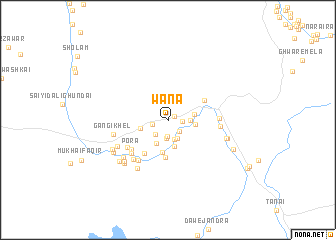
Wāna (Federally Administered Tribal Areas, Pakistan)Wāna is a town in the Federally Administered Tribal Areas region of Pakistan. An overview map of the region around Wāna is displayed below.
regional and 3d topo map of Wāna, Pakistan ::
Wāna airports ::
The nearest airport is PZH - Zhob, located 104.7 km south of Wāna.
Other airports nearby include PEW - Peshawar Intl (261.2 km north east), Nearby towns ::
Tahsīl (0.8km north east) //
Mughal Khel (1.3km east) //
Ghalja (1.6km south east) //
Khojal Khel (1.5km west) //
Pīr Makān (1.8km south) //
Karīm Khān (2.0km south) //
Dāg (1.9km south west) //
Shahwula (2.2km south east) //
Kabali Kili (2.2km south) //
Sarkarai (2.0km east) //
Kaskai (2.8km south west) //
Bazi Khel (2.5km east) //
Tāran (3.0km south) //
Si Kasa (2.5km east) //
Dab Kili (2.8km west) //
Tsappar (3.6km south) //
Sherana (4.2km south) //
Ghuzhe Pezha (4.0km north east) //
Karai (4.3km south west) //
Pora (4.7km south west) //
Kurezai (4.9km south west) //
Boki Kasa (5.0km south west) //
Dotāni Kot (5.3km south west) //
Miān Daka Kas (4.8km east) //
Hindi Kas (4.9km east) //
Sperki Wāla (5.4km south west) //
Gangi Khel (5.4km west) //
Shīn Warsak Sat (5.6km south west) //
Toji Khel (6.1km south west) //
[all distances 'as the bird flies' and approximate]  Places with similar names to Wāna, Pakistan ::
Disclaimer :: Information on this page comes without warranty of any kind |
||
|
Where is Wāna? Elevation and coordinates ::
Latitude (lat): 32°17'54"N Longitude (lon): 69°34'17"E
Elevation (approx.): 1388m (map arrows pan, magnifying glasses zoom) |
||
|
Visiting Wāna? Hotel/Accommodation ::
Book a hotel in Wāna Travel Guide ::
Buy a travel guide for Pakistan rental cars ::
car rental offers GPS waypoint ::
download a GPX waypoint (PoI) of Wāna for your GPS receiver
|
||