|
search place name
|
||
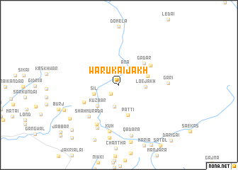
Warukai Jākh (North-West Frontier, Pakistan)Warukai Jākh is a town in the North-West Frontier region of Pakistan. An overview map of the region around Warukai Jākh is displayed below.
regional and 3d topo map of Warukai Jākh, Pakistan ::
Warukai Jākh airports ::
The nearest airport is MFG - Muzaffarabad, located 65.1 km south of Warukai Jākh.
Other airports nearby include SDT - Saidu Sharif (87.1 km west), RAZ - Rawala Kot Rawalakot (125.2 km south), ISB - Islamabad Chaklala (143.6 km south), GIL - Gilgit (146.9 km north east), Nearby towns ::
Loe Der (1.7km south west) //
Āna (2.9km north) //
Warukai Der (3.5km south) //
Loe Jākh (3.4km east) //
Sil (3.6km south west) //
Mojanr (3.9km east) //
Kuz Nar (4.3km south west) //
Patti (4.9km south) //
Gadar (4.7km north east) //
Liknai (5.1km north east) //
Charai (5.3km south west) //
Shāhmurāda (6.3km south west) //
Ghora (6.8km south west) //
Kūh (7.4km south) //
Lārai Kas (7.3km south) //
Gari (6.3km east) //
Qadara (8.2km south) //
Habīb Kas (8.4km south) //
Lundi (8.2km south west) //
Nalai Bānda (9.2km south) //
Burj (8.2km south west) //
Danna (9.4km south west) //
Narai (10.3km south west) //
Dārigai (11.1km south east) //
[all distances 'as the bird flies' and approximate]  Places with similar names to Warukai Jākh, Pakistan :: Disclaimer :: Information on this page comes without warranty of any kind |
||
|
Where is Warukai Jākh? Elevation and coordinates ::
Latitude (lat): 34°54'0"N Longitude (lon): 73°18'0"E
Elevation (approx.): 2753m (map arrows pan, magnifying glasses zoom) |
||
|
Visiting Warukai Jākh? Hotel/Accommodation ::
Book a hotel in Warukai Jākh Travel Guide ::
Buy a travel guide for Pakistan rental cars ::
car rental offers GPS waypoint ::
download a GPX waypoint (PoI) of Warukai Jākh for your GPS receiver
|
||