|
search place name
|
||
Yūsuf Shāh (Punjab, Pakistan)Yūsuf Shāh is a town in the Punjab region of Pakistan. An overview map of the region around Yūsuf Shāh is displayed below.
regional and 3d topo map of Yūsuf Shāh, Pakistan ::

Yūsuf Shāh airports ::
The nearest airport is MUX - Multan Intl, located 138.3 km south of Yūsuf Shāh.
Other airports nearby include PZH - Zhob (141.4 km west), Nearby towns ::
Basti Jutey (1.1km north west) //
Yusuf Shāh (1.1km east) //
Basti Siāl (1.4km south) //
Arāin (1.7km south west) //
Rang Shāh (2.3km south east) //
Basti Atar Dhāndla (2.7km north) //
Basti Māchhi (2.8km south) //
Basti Amīr Khān (3.1km north east) //
Basti Naurang (3.3km north) //
Rashīdpur (3.6km north) //
Buchiwāla (3.7km south) //
Rashīd Muhammad Shāh (3.6km south east) //
Sumra (3.9km south east) //
Basti Phusal (4.3km south west) //
Basti Mandrān (4.7km north) //
Samtiah (4.8km north west) //
Ganji (4.7km north east) //
Basti Sohāra (5.3km south) //
Khyber (4.8km north west) //
Dīnpur (4.7km west) //
Chuni Muhammad Hasan (4.8km east) //
Kathanwāla (5.8km north) //
T ibba Burgeānwāla (5.0km east) //
Dewāwāla (5.0km east) //
Maujūwāli (5.2km south west) //
Hazāra (6.0km north) //
Tindo (5.3km west) //
Parwānewāla (5.3km east) //
Chāh Gajarwāla (6.1km south east) //
[all distances 'as the bird flies' and approximate] 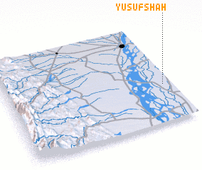 Places with similar names to Yūsuf Shāh, Pakistan ::
Disclaimer :: Information on this page comes without warranty of any kind |
||
|
Where is Yūsuf Shāh? Elevation and coordinates ::
Latitude (lat): 31°23'0"N Longitude (lon): 70°57'0"E
Elevation (approx.): 158m (map arrows pan, magnifying glasses zoom) |
||
|
Visiting Yūsuf Shāh? Hotel/Accommodation ::
Book a hotel in Yūsuf Shāh Travel Guide ::
Buy a travel guide for Pakistan rental cars ::
car rental offers GPS waypoint ::
download a GPX waypoint (PoI) of Yūsuf Shāh for your GPS receiver
|
||