|
search place name
|
||
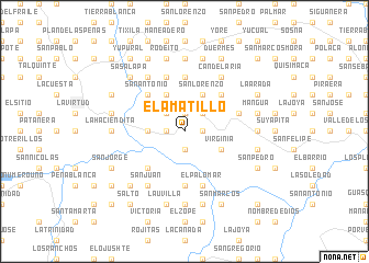
El Amatillo (Lempira, Honduras)El Amatillo is a town in the Lempira region of Honduras. An overview map of the region around El Amatillo is displayed below.
regional and 3d topo map of El Amatillo, Honduras ::
El Amatillo airports ::
The nearest airport is SAL - San Salvador El Salvador Intl, located 82.0 km south west of El Amatillo.
Other airports nearby include TGU - Tegucigalpa Toncontin Intl (149.4 km east), SAP - San Pedro Sula La Mesa Intl (173.1 km north east), GUA - Guatemala City La Aurora (216.7 km west), TEA - Tela (227.6 km north east), Nearby towns ::
El Rodeo (1.9km south) //
Los Hernández (1.9km south) //
El Castaño (1.8km east) //
Cerro Grande (1.8km east) //
Agua Caliente (1.9km north) //
Guajiniquil (1.9km north) //
Carrizal (1.9km north) //
Mapulaca (1.8km west) //
Los González (2.6km north east) //
La Tabla (2.6km north west) //
El Palmito (2.6km north west) //
Llano de la Hamaca (3.6km west) //
Llano Grande (4.0km south east) //
Virginia (4.0km south east) //
El Cacahuatal (4.1km north east) //
San Lorenzo (4.1km north east) //
Comapara (4.1km north east) //
La Majada (4.1km north east) //
La Vecina (4.1km north west) //
Las Dantas (5.2km south west) //
San Francisco (5.2km north east) //
San Antonio (5.2km north west) //
Los Metales (5.6km north) //
El Limo (5.6km south) //
El Palomar (5.8km south) //
El Zapote (5.7km east) //
Cacahuatal (5.8km north) //
Candelaria (6.6km north east) //
El Salamo (6.6km north west) //
[all distances 'as the bird flies' and approximate]  Places with similar names to El Amatillo, Honduras ::
Disclaimer :: Information on this page comes without warranty of any kind |
||
|
Where is El Amatillo? Elevation and coordinates ::
Latitude (lat): 14°2'0"N Longitude (lon): 88°36'0"W
Elevation (approx.): 260m (map arrows pan, magnifying glasses zoom) |
||
|
Visiting El Amatillo? Hotel/Accommodation ::
Book a hotel in El Amatillo Travel Guide ::
Buy a travel guide for Honduras rental cars ::
car rental offers GPS waypoint ::
download a GPX waypoint (PoI) of El Amatillo for your GPS receiver
|
||