|
search place name
|
||
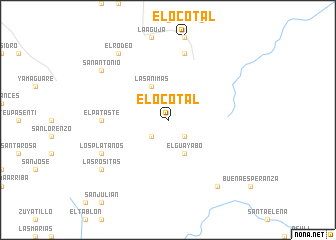
El Ocotal (El Paraíso, Honduras)El Ocotal is a town in the El Paraíso region of Honduras. An overview map of the region around El Ocotal is displayed below.
regional and 3d topo map of El Ocotal, Honduras ::
El Ocotal airports ::
The nearest airport is TGU - Tegucigalpa Toncontin Intl, located 74.1 km west of El Ocotal.
Other airports nearby include LCE - La Ceiba Goloson Intl (171.9 km north), TEA - Tela (199.2 km north west), SAP - San Pedro Sula La Mesa Intl (201.4 km north west), Nearby towns ::
Travesías (2.6km south east) //
Buena Vista (2.6km south west) //
Las Ánimas (4.1km north west) //
El Guayabo (4.1km south east) //
El Pataste (7.2km west) //
Plan Grande (7.6km north) //
El Corralito (7.6km north) //
Los Plátanos (8.1km south west) //
El Rodeo (9.2km north west) //
Azabache (9.2km south east) //
Las Rositas (9.1km south west) //
San Antonio (9.1km north west) //
[all distances 'as the bird flies' and approximate] 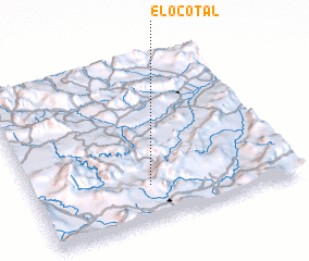 Places with similar names to El Ocotal, Honduras ::
// Elkdale (US)
// Elkdale (US)
// Elkdale (US)
// El Cadillo (CO)
// El Guadual (CO)
// El Guadual (CO)
// El Cutal (SV)
// El Ocotal (SV)
// El Cadillo (MX)
// El Gatal (MX)
Disclaimer :: Information on this page comes without warranty of any kind |
||
|
Where is El Ocotal? Elevation and coordinates ::
Latitude (lat): 14°13'0"N Longitude (lon): 86°33'0"W
Elevation (approx.): 832m (map arrows pan, magnifying glasses zoom) |
||
|
Visiting El Ocotal? Hotel/Accommodation ::
Book a hotel in El Ocotal Travel Guide ::
Buy a travel guide for Honduras rental cars ::
car rental offers GPS waypoint ::
download a GPX waypoint (PoI) of El Ocotal for your GPS receiver
|
||