|
search place name
|
||
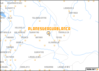
Planes de Agua Blanca (Atlántida, Honduras)Planes de Agua Blanca is a town in the Atlántida region of Honduras. An overview map of the region around Planes de Agua Blanca is displayed below.
regional and 3d topo map of Planes de Agua Blanca, Honduras ::
Planes de Agua Blanca airports ::
The nearest airport is SAP - San Pedro Sula La Mesa Intl, located 28.7 km south west of Planes de Agua Blanca.
Other airports nearby include TEA - Tela (32.1 km north east), LCE - La Ceiba Goloson Intl (91.1 km east), RTB - Roatan Juan Manuel Galvez Intl (149.4 km north east), TGU - Tegucigalpa Toncontin Intl (174.0 km south), Nearby towns ::
Cueva del Tigre (0.0km north) //
Santa Rosa del Norte (2.6km south east) //
Mezapa (4.0km north east) //
Toyós (4.0km south east) //
El Naranjo (4.1km south east) //
Crike Amarillo (4.1km south west) //
Bataán (4.0km south west) //
Guaimitas (5.4km west) //
Tarraloza (5.4km east) //
Toloa Adentro (6.6km north west) //
Guaimitas (8.2km south west) //
[all distances 'as the bird flies' and approximate] 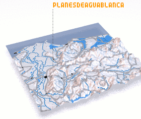 Places with similar names to Planes de Agua Blanca, Honduras :: Disclaimer :: Information on this page comes without warranty of any kind |
||
|
Where is Planes de Agua Blanca? Elevation and coordinates ::
Latitude (lat): 15°34'0"N Longitude (lon): 87°41'0"W
Elevation (approx.): 39m (map arrows pan, magnifying glasses zoom) |
||
|
Visiting Planes de Agua Blanca? Hotel/Accommodation ::
Book a hotel in Planes de Agua Blanca Travel Guide ::
Buy a travel guide for Honduras rental cars ::
car rental offers GPS waypoint ::
download a GPX waypoint (PoI) of Planes de Agua Blanca for your GPS receiver
|
||