|
search place name
|
||
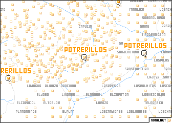
Potrerillos (El Paraíso, Honduras)Potrerillos is a town in the El Paraíso region of Honduras. An overview map of the region around Potrerillos is displayed below.
regional and 3d topo map of Potrerillos, Honduras ::
Potrerillos airports ::
The nearest airport is TGU - Tegucigalpa Toncontin Intl, located 59.7 km north of Potrerillos.
Other airports nearby include MGA - Managua Intl (183.0 km south east), SAL - San Salvador El Salvador Intl (215.6 km west), SAP - San Pedro Sula La Mesa Intl (230.8 km north west), Nearby towns ::
Bocuire (0.4km north east) //
El Barrial (0.8km north east) //
El Hato Viejo (0.9km south west) //
El Matiaral (0.9km west) //
Jocomico (1.1km south) //
El Patillal (1.3km north east) //
El Uvillal (1.6km south west) //
El Capulín (1.8km north west) //
Los Mangos (1.9km west) //
El Calero (1.9km east) //
Loma del Arado (2.0km north east) //
El Tronconal (2.2km south west) //
El Jicarito (2.2km west) //
Piedra de Campana (2.3km north west) //
Quebrada de Agua (2.4km north) //
El Jocote (2.5km east) //
El Potrero (2.6km south east) //
Los Canales (2.6km south west) //
Loma del Angel (2.6km north east) //
Trancas del Potrero (2.7km north east) //
Las Sabanitas (2.7km south east) //
La Rinconada (2.7km west) //
Liure (2.7km west) //
Guailo (2.8km north) //
Canta Gallo (2.9km north west) //
Tierra Colorada (2.9km north west) //
Paso de Los López (3.0km north west) //
Las Marías (3.0km south east) //
El Espino (3.0km west) //
[all distances 'as the bird flies' and approximate]  Places with similar names to Potrerillos, Honduras ::
// Potrerillos (PA)
// Potrerillos (CL)
// Potrerillos (CO)
// Potrerillos (CR)
// Potrerillos (CR)
// Potrerillos (CR)
// Potrerillos (CR)
// Potrerillos (CR)
// Potrerillos (SV)
// Potrerillos (SV)
Disclaimer :: Information on this page comes without warranty of any kind |
||
|
Where is Potrerillos? Elevation and coordinates ::
Latitude (lat): 13°32'28"N Longitude (lon): 87°4'2"W
Elevation (approx.): 260m (map arrows pan, magnifying glasses zoom) |
||
|
Visiting Potrerillos? Hotel/Accommodation ::
Book a hotel in Potrerillos Travel Guide ::
Buy a travel guide for Honduras rental cars ::
car rental offers GPS waypoint ::
download a GPX waypoint (PoI) of Potrerillos for your GPS receiver
|
||