|
search place name
|
||
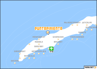
Punta Pimienta (Islas de la Bahía, Honduras)Punta Pimienta is a town in the Islas de la Bahía region of Honduras. An overview map of the region around Punta Pimienta is displayed below.
regional and 3d topo map of Punta Pimienta, Honduras ::
Punta Pimienta airports ::
The nearest airport is RTB - Roatan Juan Manuel Galvez Intl, located 5.6 km south of Punta Pimienta.
Other airports nearby include GJA - Guanaja (67.5 km east), LCE - La Ceiba Goloson Intl (77.1 km south west), TEA - Tela (120.2 km south west), SAP - San Pedro Sula La Mesa Intl (180.0 km south west), Nearby towns ::
Dixonʼs Cove (4.0km south east) //
Man of War Cay (4.0km south west) //
Brick Bay (5.1km south east) //
Mud Hole (5.1km south west) //
Coconut Garden (5.6km south) //
Thatch Point (5.8km south) //
Dixon Cove (5.8km south) //
Corozal (5.8km south) //
Sandy Bay (6.6km south west) //
Roatán (7.6km south) //
Antoneys Cay (8.0km south west) //
Watering Place (8.2km south west) //
Gravel Bay (9.1km south west) //
[all distances 'as the bird flies' and approximate] 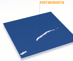 Places with similar names to Punta Pimienta, Honduras :: Disclaimer :: Information on this page comes without warranty of any kind |
||
|
Where is Punta Pimienta? Elevation and coordinates ::
Latitude (lat): 16°22'0"N Longitude (lon): 86°32'0"W
Elevation (approx.): -32768m (map arrows pan, magnifying glasses zoom) |
||
|
Visiting Punta Pimienta? Hotel/Accommodation ::
Book a hotel in Punta Pimienta Travel Guide ::
Buy a travel guide for Honduras rental cars ::
car rental offers GPS waypoint ::
download a GPX waypoint (PoI) of Punta Pimienta for your GPS receiver
|
||