|
search place name
|
||
Río Abajo (Choluteca, Honduras)Río Abajo is a town in the Choluteca region of Honduras. An overview map of the region around Río Abajo is displayed below.
regional and 3d topo map of Río Abajo, Honduras ::

Río Abajo airports ::
The nearest airport is TGU - Tegucigalpa Toncontin Intl, located 104.1 km north of Río Abajo.
Other airports nearby include MGA - Managua Intl (143.4 km south east), Nearby towns ::
Jocote (1.2km south) //
Los Matapalos (1.3km north west) //
Las Uvas (2.0km south west) //
Las Chapernas (2.1km north) //
Las Chacaras (2.2km south) //
El Perico (2.7km west) //
Las Chapernas (3.0km south) //
El Triunfo (3.0km south) //
Río Grande (3.2km north west) //
Santa Teresa (3.4km west) //
Los Coyotes (3.7km south west) //
Tierra Colorada (3.7km south west) //
La Mina (3.9km south) //
La Ceiba (3.9km south east) //
La Calera (3.9km south east) //
Las Marías (4.6km north) //
El Pacón (4.6km north) //
Santa Cruz (4.5km east) //
El Portillo (4.8km south) //
Las Pilas (4.8km south) //
La Ceibilla (4.8km south) //
La Pabellona (4.9km north) //
Pabellona (4.9km north) //
La Tigra (5.3km south east) //
Los Aguacates (5.3km north west) //
La Joya (5.6km north) //
Santa María (5.5km west) //
Los Matapalos (5.6km north west) //
Río Arriba (5.8km north west) //
[all distances 'as the bird flies' and approximate] 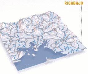 Places with similar names to Río Abajo, Honduras ::
Disclaimer :: Information on this page comes without warranty of any kind |
||
|
Where is Río Abajo? Elevation and coordinates ::
Latitude (lat): 13°8'33"N Longitude (lon): 87°0'27"W
Elevation (approx.): 141m (map arrows pan, magnifying glasses zoom) |
||
|
Visiting Río Abajo? Hotel/Accommodation ::
Book a hotel in Río Abajo Travel Guide ::
Buy a travel guide for Honduras rental cars ::
car rental offers GPS waypoint ::
download a GPX waypoint (PoI) of Río Abajo for your GPS receiver
|
||