|
search place name
|
||
Río Chiquito (Yoro, Honduras)Río Chiquito is a town in the Yoro region of Honduras. An overview map of the region around Río Chiquito is displayed below.
regional and 3d topo map of Río Chiquito, Honduras ::

Río Chiquito airports ::
The nearest airport is SAP - San Pedro Sula La Mesa Intl, located 13.8 km north west of Río Chiquito.
Other airports nearby include TEA - Tela (56.8 km north east), LCE - La Ceiba Goloson Intl (110.7 km east), TGU - Tegucigalpa Toncontin Intl (159.9 km south east), RTB - Roatan Juan Manuel Galvez Intl (172.8 km north east), Nearby towns ::
Buena Vista (0.0km north) //
Quebrada Seca (2.6km south east) //
Monte Vista Campo (2.6km north west) //
El Progreso (2.6km north east) //
Monte Vista (3.6km west) //
Omonita Campo (3.6km west) //
Camalote Abajo (3.6km east) //
Omonita (4.0km south west) //
Corozal (4.1km north west) //
El Porvenir (4.0km north east) //
Mopala (5.1km north west) //
Cobb (5.1km north west) //
El Paraíso (5.7km east) //
Río Pelo (5.8km south) //
Campín (6.5km south west) //
El Barro (6.5km south west) //
Playa del Padre (6.5km north west) //
Quebrada de Yoro (6.6km north east) //
Nana Chumba (7.4km north) //
La Mina (7.6km south) //
Naranjo Chino (7.6km north) //
Buenos Aires (8.2km south east) //
La Mesa (8.1km north west) //
Playa de Indios (8.2km north west) //
Santa Marta (8.1km south east) //
La Unión (9.1km south east) //
San Juan Tacamiche (9.1km north west) //
Travesía (9.1km south west) //
Camalote (9.1km north east) //
[all distances 'as the bird flies' and approximate] 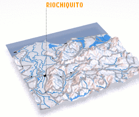 Places with similar names to Río Chiquito, Honduras ::
// Rio Chiquito (US)
// Río Chiquito (CO)
// Río Chiquito (CO)
// Río Chiquito (CR)
// Río Chiquito (SV)
// Río Chiquito (GT)
// Río Chiquito (GT)
// Río Chiquito (GT)
// Río Chiquito (MX)
// Río Chiquito (MX)
Disclaimer :: Information on this page comes without warranty of any kind |
||
|
Where is Río Chiquito? Elevation and coordinates ::
Latitude (lat): 15°23'0"N Longitude (lon): 87°49'0"W
Elevation (approx.): 35m (map arrows pan, magnifying glasses zoom) |
||
|
Visiting Río Chiquito? Hotel/Accommodation ::
Book a hotel in Río Chiquito Travel Guide ::
Buy a travel guide for Honduras rental cars ::
car rental offers GPS waypoint ::
download a GPX waypoint (PoI) of Río Chiquito for your GPS receiver
|
||