|
search place name
|
||
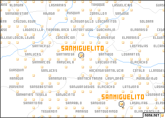
San Miguelito (Intibucá, Honduras)San Miguelito is a town in the Intibucá region of Honduras. An overview map of the region around San Miguelito is displayed below.
regional and 3d topo map of San Miguelito, Honduras ::
San Miguelito airports ::
The nearest airport is SAL - San Salvador El Salvador Intl, located 102.5 km south west of San Miguelito.
Other airports nearby include TGU - Tegucigalpa Toncontin Intl (117.2 km east), SAP - San Pedro Sula La Mesa Intl (165.8 km north), TEA - Tela (215.6 km north east), LCE - La Ceiba Goloson Intl (247.8 km north east), Nearby towns ::
El Apintal (0.0km north) //
La Jagua (0.0km north) //
Santa Cruz (0.0km north) //
San Ignacio (1.9km south) //
Buenos Aires (1.9km south) //
San Isidro (1.8km west) //
El Rincón (1.8km east) //
Concepción de Camasca (1.8km west) //
El Cerrón (1.8km west) //
Las Piletas (1.8km west) //
El Paraíso (1.8km west) //
Santo Domingo (2.6km north east) //
Guachipilincito (2.6km south east) //
Candelarita (2.6km north west) //
La Laguna (2.6km south east) //
El Guarumo (3.6km east) //
San Jerónimo (3.7km north) //
Cacauchagua (3.7km south) //
Santa Rosa (3.6km west) //
Aradilla (4.1km north east) //
Los Uvillos (4.1km north west) //
El Rodeo (4.1km north east) //
El Carmen (4.1km south east) //
Guayabal (4.1km south east) //
Maruchila (4.0km south west) //
Cotalá (5.2km north east) //
Concepción (5.2km north west) //
La Micaela (5.2km north west) //
San Juan (5.2km north west) //
[all distances 'as the bird flies' and approximate]  Places with similar names to San Miguelito, Honduras ::
// San Miguelito (PA)
// San Miguelito (CO)
// San Miguelito (CO)
// San Miguelito (EC)
// San Miguelito (SV)
// San Miguelito (SV)
// San Miguelito (SV)
// San Miguelito (SV)
// San Miguelito (GT)
// San Miguelito (GT)
Disclaimer :: Information on this page comes without warranty of any kind |
||
|
Where is San Miguelito? Elevation and coordinates ::
Latitude (lat): 14°0'0"N Longitude (lon): 88°18'0"W
Elevation (approx.): 722m (map arrows pan, magnifying glasses zoom) |
||
|
Visiting San Miguelito? Hotel/Accommodation ::
Book a hotel in San Miguelito Travel Guide ::
Buy a travel guide for Honduras rental cars ::
car rental offers GPS waypoint ::
download a GPX waypoint (PoI) of San Miguelito for your GPS receiver
|
||