|
search place name
|
||
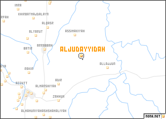
Al Judayyidah (Al Karak, Jordan)Al Judayyidah is a town in the Al Karak region of Jordan. An overview map of the region around Al Judayyidah is displayed below.
regional and 3d topo map of Al Judayyidah, Jordan ::
Al Judayyidah airports ::
The nearest airport is AMM - Amman Queen Alia Intl, located 55.0 km north of Al Judayyidah.
Other airports nearby include ADJ - Amman Marka Intl (81.8 km north), BEV - Beer-sheba Teyman (104.2 km west), TLV - Tel-aviv Ben Gurion (122.1 km north west), OMF - Mafraq King Hussein (129.6 km north), Nearby towns ::
As Simākīyah (5.8km north) //
Al Ḩamūd (5.8km north) //
Al Lajjūn (5.1km east) //
Adir (7.3km south west) //
Ar Rabbah (7.8km west) //
Al Qaşr (9.9km north west) //
Al Manshīyah (10.0km south west) //
[all distances 'as the bird flies' and approximate]  Places with similar names to Al Judayyidah, Jordan ::
// Al Jadīdah (IQ)
// Al Jadīdah (IQ)
// Al Jadīdah (EG)
// Al Judayyidah (EG)
// Al Jadīdah (TN)
// Al Judaydah (LB)
// Al Jadīdah (SA)
// Al Jadīdah (SA)
// Al Jadīdah (SA)
// Al Jadīdah (SA)
Disclaimer :: Information on this page comes without warranty of any kind |
||
|
Where is Al Judayyidah? Elevation and coordinates ::
Latitude (lat): 31°15'0"N Longitude (lon): 35°49'0"E
Elevation (approx.): 891m (map arrows pan, magnifying glasses zoom) |
||
|
Visiting Al Judayyidah? Hotel/Accommodation ::
Book a hotel in Al Judayyidah Travel Guide ::
Buy a travel guide for Jordan rental cars ::
car rental offers GPS waypoint ::
download a GPX waypoint (PoI) of Al Judayyidah for your GPS receiver
|
||