|
search place name
|
||
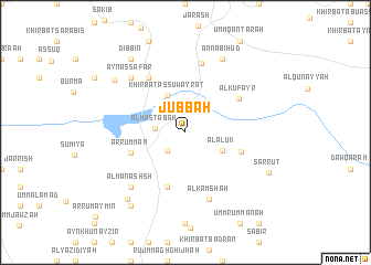
Jubbah (Jordan)Jubbah is a town in Jordan. An overview map of the region around Jubbah is displayed below.
regional and 3d topo map of Jubbah, Jordan ::
Jubbah airports ::
The nearest airport is ADJ - Amman Marka Intl, located 25.5 km south east of Jubbah.
Other airports nearby include OMF - Mafraq King Hussein (40.3 km north east), AMM - Amman Queen Alia Intl (52.1 km south), RPN - Rosh Pina Mahanaim I Ben Yaakov (93.2 km north), TLV - Tel-aviv Ben Gurion (96.0 km west), Nearby towns ::
Tal‘at ar Ruzz (2.4km south west) //
Al Maşţabah (2.6km west) //
Khirbat as Suwayrāt (4.0km north west) //
Al ‘Ālūk (3.6km south east) //
Murşi‘ (5.8km south) //
Ar Rummān (5.1km south west) //
Al Masarrah (5.2km east) //
Al Kufayr (5.7km north east) //
Al Majdal (6.4km north west) //
Al Kamshah (7.0km south) //
Ar Rashāʼidah (7.2km north) //
‘Ayn aş Şafār (7.3km north west) //
Al Manashsh (7.3km south west) //
An Nabī Hūd (8.0km north east) //
As Salīḩī (8.3km south west) //
Al Jazzāzah (8.1km north west) //
Umm Tall (8.8km south west) //
Dibbīn (8.8km north west) //
Şarrūt (8.2km south east) //
[all distances 'as the bird flies' and approximate]  Places with similar names to Jubbah, Jordan ::
Disclaimer :: Information on this page comes without warranty of any kind |
||
|
Where is Jubbah? Elevation and coordinates ::
Latitude (lat): 32°11'0"N Longitude (lon): 35°53'0"E
Elevation (approx.): 650m (map arrows pan, magnifying glasses zoom) |
||
|
Visiting Jubbah? Hotel/Accommodation ::
Book a hotel in Jubbah Travel Guide ::
Buy a travel guide for Jordan rental cars ::
car rental offers GPS waypoint ::
download a GPX waypoint (PoI) of Jubbah for your GPS receiver
|
||