|
search place name
|
||
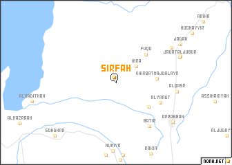
Şirfah (Al Karak, Jordan)Şirfah is a town in the Al Karak region of Jordan. An overview map of the region around Şirfah is displayed below.
regional and 3d topo map of Şirfah, Jordan ::
Şirfah airports ::
The nearest airport is AMM - Amman Queen Alia Intl, located 54.2 km north east of Şirfah.
Other airports nearby include ADJ - Amman Marka Intl (78.3 km north east), BEV - Beer-sheba Teyman (88.9 km west), TLV - Tel-aviv Ben Gurion (105.2 km north west), SDV - Tel-aviv Sde Dov (120.3 km north west), Nearby towns ::
 Places with similar names to Şirfah, Jordan ::
Disclaimer :: Information on this page comes without warranty of any kind |
||
|
Where is Şirfah? Elevation and coordinates ::
Latitude (lat): 31°19'41"N Longitude (lon): 35°39'21"E
Elevation (approx.): 946m (map arrows pan, magnifying glasses zoom) |
||
|
Visiting Şirfah? Hotel/Accommodation ::
Book a hotel in Şirfah Travel Guide ::
Buy a travel guide for Jordan rental cars ::
car rental offers GPS waypoint ::
download a GPX waypoint (PoI) of Şirfah for your GPS receiver
|
||