|
search place name
|
||
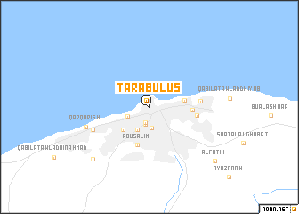
Ţarābulus (Ţarābulus, Libya)Ţarābulus is a town in the Ţarābulus region of Libya. An overview map of the region around Ţarābulus is displayed below.
regional and 3d topo map of Ţarābulus, Libya ::
Ţarābulus airports ::
The nearest airport is TIP - Tripoli Intl, located 25.5 km south of Ţarābulus.
Nearby towns ::
Bāb al ‘Azīzīyah (2.0km south) //
Bāb ‘Akkārah (2.3km south) //
Qaryat al Baladīyah (2.6km south) //
Bāb Qarqārish (2.6km south west) //
Mu‘askar Jālū (3.1km south west) //
Qurjī (4.0km south west) //
Bū Sittah (3.8km east) //
Abū Salīm (4.9km south) //
Bāb Tājūrāʼ (4.5km east) //
Sūq al Jum‘ah (5.1km east) //
Al Hanshīr (5.4km east) //
Hayy al Andalus (6.6km south west) //
Qarqārish (7.2km west) //
Awlād Bin Aḩmad (8.8km south west) //
Al Fātiḩ (9.6km south east) //
[all distances 'as the bird flies' and approximate] 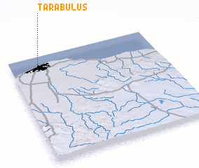 Places with similar names to Ţarābulus, Libya ::
// Trablice (PL)
// Turballos (ES)
// Dawwār Abū al ‘Āşī (EG)
// Trâblous (LB)
// Třebelice (CZ)
// Troubelice (CZ)
Disclaimer :: Information on this page comes without warranty of any kind |
||
|
Where is Ţarābulus? Elevation and coordinates ::
Latitude (lat): 32°53'33"N Longitude (lon): 13°10'48"E
Elevation (approx.): 7m (map arrows pan, magnifying glasses zoom) |
||
|
Visiting Ţarābulus? Hotel/Accommodation ::
Book a hotel in Ţarābulus Travel Guide ::
Buy a travel guide for Libya rental cars ::
car rental offers GPS waypoint ::
download a GPX waypoint (PoI) of Ţarābulus for your GPS receiver
|
||