|
search place name
|
||
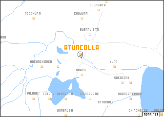
Atuncolla (Puno, Peru)Atuncolla is a town in the Puno region of Peru. An overview map of the region around Atuncolla is displayed below.
regional and 3d topo map of Atuncolla, Peru ::
Atuncolla airports ::
The nearest airport is JUL - Juliaca, located 23.9 km north of Atuncolla.
Other airports nearby include AQP - Arequipa Rodriguez Ballon (169.8 km south west), LPB - La Paz El Alto Intl (228.7 km south east), Nearby towns ::
Umayo (3.7km south) //
Llungo (5.7km west) //
Buena Vista (5.8km north) //
Ylpa (7.4km east) //
[all distances 'as the bird flies' and approximate]  Places with similar names to Atuncolla, Peru ::
// Ad Danāqilah (EG)
// Aydınoğlu (TR)
// Ādīngol (IR)
// Atinekeli (CD)
// Attingal (IN)
// Atinggola (ID)
// Atenguillo (MX)
// Adiāna Gala (PK)
// Atuncole (PE)
// Adonkolo (NG)
Disclaimer :: Information on this page comes without warranty of any kind |
||
|
Where is Atuncolla? Elevation and coordinates ::
Latitude (lat): 15°41'0"S Longitude (lon): 70°9'0"W
Elevation (approx.): 3833m (map arrows pan, magnifying glasses zoom) |
||
|
Visiting Atuncolla? Hotel/Accommodation ::
Book a hotel in Atuncolla Travel Guide ::
Buy a travel guide for Peru rental cars ::
car rental offers GPS waypoint ::
download a GPX waypoint (PoI) of Atuncolla for your GPS receiver
|
||