|
search place name
|
||
Banda (Arequipa, Peru)Banda is a town in the Arequipa region of Peru. An overview map of the region around Banda is displayed below.
regional and 3d topo map of Banda, Peru ::

Banda airports ::
The nearest airport is ANS - Andahuaylas, located 225.5 km north of Banda.
Nearby towns ::
Hacienda Arasqui (0.6km north east) //
Rastrojal (0.7km south east) //
Alto de la Luna (1.1km south) //
Animas (2.0km north east) //
Victoria (2.2km south west) //
Media Noche (2.8km north east) //
El Convento (3.6km south) //
Chiuchine (3.7km north) //
Tiruque (3.7km north east) //
Repartición (4.7km south) //
Calaparca (4.9km south west) //
El Molino (5.8km north) //
San Silvestre (5.9km south) //
Solares (6.0km south west) //
Alto Perú (6.6km south) //
Cháparra (6.6km south west) //
Andenes (7.1km south west) //
Pampa Grande (7.5km south west) //
Chota (7.8km south west) //
Quicacha (7.9km north) //
Sausales (7.9km south west) //
San Andrés (8.0km south west) //
Torrecillas (10.6km south east) //
Socavon (10.7km south west) //
Huara Grande (10.7km south west) //
Cajon Grande (11.0km south west) //
Hacienda la Estrella (11.1km south west) //
Huanal (11.2km south west) //
Huara (11.2km south west) //
[all distances 'as the bird flies' and approximate] 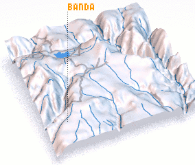 Places with similar names to Banda, Peru ::
Disclaimer :: Information on this page comes without warranty of any kind |
||
|
Where is Banda? Elevation and coordinates ::
Latitude (lat): 15°41'30"S Longitude (lon): 73°49'33"W
Elevation (approx.): 1385m (map arrows pan, magnifying glasses zoom) |
||
|
Visiting Banda? Hotel/Accommodation ::
Book a hotel in Banda Travel Guide ::
Buy a travel guide for Peru rental cars ::
car rental offers GPS waypoint ::
download a GPX waypoint (PoI) of Banda for your GPS receiver
|
||