|
search place name
|
||
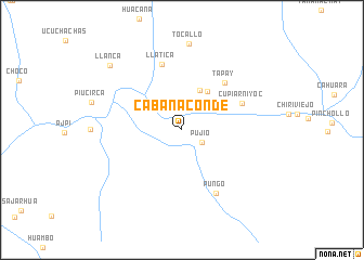
Cabanaconde (Arequipa, Peru)Cabanaconde is a town in the Arequipa region of Peru. An overview map of the region around Cabanaconde is displayed below.
regional and 3d topo map of Cabanaconde, Peru ::
Cabanaconde airports ::
The nearest airport is AQP - Arequipa Rodriguez Ballon, located 90.2 km south east of Cabanaconde.
Other airports nearby include JUL - Juliaca (196.1 km east), ANS - Andahuaylas (258.3 km north west), Nearby towns ::
Pujío (2.4km south east) //
Malata (4.4km north east) //
Cosnihua (4.8km north east) //
Tapay (6.4km north east) //
Cupiarniyoc (6.6km north east) //
Llatica (7.0km north) //
Pungo (7.3km south east) //
Tocallo (8.9km north) //
Llanca (9.8km north west) //
[all distances 'as the bird flies' and approximate] 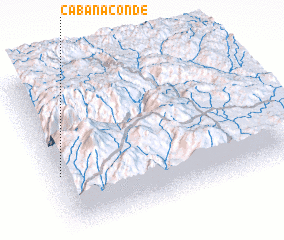 Places with similar names to Cabanaconde, Peru ::
// Cabañaquinta (ES)
// Kabingandu (CD)
// Qabān Kandī (IR)
// Cabancunda (MZ)
// Cabancunda (MZ)
// Çobankǝnd (AZ)
Disclaimer :: Information on this page comes without warranty of any kind |
||
|
Where is Cabanaconde? Elevation and coordinates ::
Latitude (lat): 15°37'17"S Longitude (lon): 71°58'44"W
Elevation (approx.): 3307m (map arrows pan, magnifying glasses zoom) |
||
|
Visiting Cabanaconde? Hotel/Accommodation ::
Book a hotel in Cabanaconde Travel Guide ::
Buy a travel guide for Peru rental cars ::
car rental offers GPS waypoint ::
download a GPX waypoint (PoI) of Cabanaconde for your GPS receiver
|
||