|
search place name
|
||
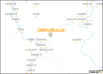
Carrizalillo (Tumbes, Peru)Carrizalillo is a town in the Tumbes region of Peru. An overview map of the region around Carrizalillo is displayed below.
regional and 3d topo map of Carrizalillo, Peru ::
Carrizalillo airports ::
The nearest airport is TBP - Tumbes Pedro Canga, located 39.8 km north east of Carrizalillo.
Other airports nearby include MCH - Machala General Manuel Serrano (94.3 km north east), TYL - Talara Capitan Montes (109.6 km south west), PIU - Piura Capitan Fap Guillermo Concha Iberico (150.0 km south), SNC - Salinas General Ulpiano Paez (187.4 km north), Nearby towns ::
La Bocana (4.1km south west) //
Tamarindo (4.1km south west) //
San Miguel (5.2km south west) //
Pampa El Toro (5.9km south) //
La Tranca (5.8km west) //
Avería (7.6km west) //
Rica Playa (9.3km north east) //
Huaquilla (9.3km south west) //
Ánimas (9.3km north west) //
El Valiente (9.3km south west) //
[all distances 'as the bird flies' and approximate] 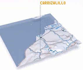 Places with similar names to Carrizalillo, Peru ::
// Carricillal (PA)
// Carrizalillo (CL)
// Carrizalillo (CL)
// Carrizalillo (CL)
// Carrizalillo (MX)
// Carrizalillo (MX)
// Carrizalillo (MX)
// Carrizalillo (MX)
// Carrizalillo (MX)
// Carrizalillo (MX)
Disclaimer :: Information on this page comes without warranty of any kind |
||
|
Where is Carrizalillo? Elevation and coordinates ::
Latitude (lat): 3°51'0"S Longitude (lon): 80°35'0"W
Elevation (approx.): 253m (map arrows pan, magnifying glasses zoom) |
||
|
Visiting Carrizalillo? Hotel/Accommodation ::
Book a hotel in Carrizalillo Travel Guide ::
Buy a travel guide for Peru rental cars ::
car rental offers GPS waypoint ::
download a GPX waypoint (PoI) of Carrizalillo for your GPS receiver
|
||