|
search place name
|
||
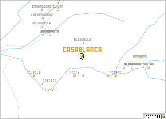
Casa Blanca (Ancash, Peru)Casa Blanca is a town in the Ancash region of Peru. An overview map of the region around Casa Blanca is displayed below.
regional and 3d topo map of Casa Blanca, Peru ::
Casa Blanca airports ::
The nearest airport is CHM - Chimbote Teniente Jaime A De Montreuil Morales, located 57.8 km north west of Casa Blanca.
Other airports nearby include ATA - Anta Comandante Fap German Arias Graziani (61.1 km east), TRU - Trujillo Capitan Carlos Martinez De Pinillos (190.1 km north west), Nearby towns ::
Navín (3.7km south) //
El Camello (3.7km north) //
Pacay (4.1km south west) //
Jaigua (6.6km south east) //
Cocopoto (8.2km south east) //
Poctao (8.2km south east) //
Buenavista (9.2km north west) //
Patazca (9.2km south west) //
Choloque (10.4km south west) //
Puquio (10.4km south west) //
[all distances 'as the bird flies' and approximate] 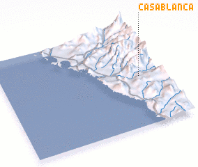 Places with similar names to Casa Blanca, Peru ::
// Casa Blanca (US)
// Casa Blanca (US)
// Casa Blanco (US)
// Casa Blanca (PA)
// Casa Blanca (CU)
// Casablanca (CU)
// Casablanca (CU)
// Casa Blanca (ES)
// Casa Blanca (ES)
// Casa Blanca (ES)
Disclaimer :: Information on this page comes without warranty of any kind |
||
|
Where is Casa Blanca? Elevation and coordinates ::
Latitude (lat): 9°30'0"S Longitude (lon): 78°8'0"W
Elevation (approx.): 378m (map arrows pan, magnifying glasses zoom) |
||
|
Visiting Casa Blanca? Hotel/Accommodation ::
Book a hotel in Casa Blanca Travel Guide ::
Buy a travel guide for Peru rental cars ::
car rental offers GPS waypoint ::
download a GPX waypoint (PoI) of Casa Blanca for your GPS receiver
|
||